Travel Reference
In-Depth Information
Safed
7
Road map
C2.
*
26,000.
@
n
Town Hall, (04) 680 1465.
The highest town in Israel,
Safed is also one of the four
holy cities of theTalmud,
together with Jerusalem,
Hebron and Tiberias. In the
Middle Ages Safed became a
popular meeting place for
many groups of Sephardic
Jews who had been driven
out of Spain in the course of
the Christian Reconquest.
Religious schools were
founded and many interpreters
of the Kabbalah lived in the
town. Tothis day Safed has
remained an important centre
of Jewish religious studies.
Safed covers a number of
small hilltops, with its
attractive old town centre
located around the slopes of
Gan ha-Metusda, once the
site of a Crusader citadel. The
old quarters of the town centre
are best explored on foot, via
their narrow streets and steep
stairways. The Synagogue
Quarter has many interesting
Kabbalist synagogues including
those of Itzhak Luria, Itzhak
Abuhav and Joseph Caro. The
former Arab Quarter (which
became Jewish in 1948) is now
home to a large colony of
artists and is known as the
Artists' Quarter. In the narrow
streets and alleys between the
area's picturesque houses,
artists display their paintings
and sculptures. Many also use
their own homes as galleries.
of narrow alleys where you
can find a wide range of
unusual goods.
Built in 1969 over the ruins
of the original Byzantine
church, and the successive
Crusader one, the
Basilica of
the Annunciation
is the major
focal point in Nazareth. A
bold, modern church, its
large dome towers over the
town. The crypt includes the
Cave of the Annunciation,
where the angel Gabriel is
said to have appeared to Mary.
A peaceful garden leads to
St Joseph's
, a small church,
rebuilt in 1914 on what is
thought to be the site of
Joseph's home and workshop.
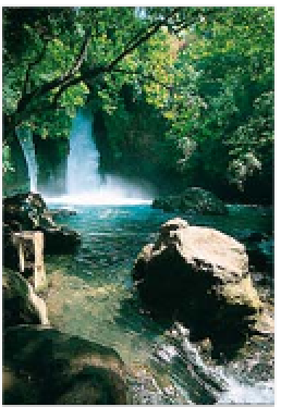
Banias Falls, Golan Heights
Golan Heights
8
Road map
C2
.
@
to Katsrin.
n
(04) 685 1010.
www
.tour.golan.org.il
This region of long-running
historical conflict has
nevertheless got much to
recommend it. A high fertile
plateau, dominated by Mount
Hermon, it borders Israel,
Syria, Jordan and Lebanon.
This unique geography, aside
from making it strategically
important, also makes it a
spectacular place to visit, with
incredible vistas all around.
A major source of the Jordan
River, one of the most pop-
ular places to visit is
Banias
,
15 km (9 miles) east of Kiryat
Shmona. Here a large spring
cascades downstream to the
attractive Banias Falls nearby.
Nimrud Castle
, a short way to
the northeast, originates from
biblical times, though it
owes its present shape to the
rule of the Mameluke sultan
Baybars I (1260-77). Nine of
the defensive towers remain,
along with much of the outer
wall,akeep, and the moat.
In the south of the Golan is
the administrative capital of
Katsrin
. Founded as an Israeli
settlement in 1974,the town
itself is unremarkable, but is a
good base for exploring the
beautiful countryside around.
This is ideal hiking country,
and the spectacular
Yehudiya
Reserve
to the south of
Katsrin is well worth a visit.
T
Nimrud Castle
26 km (16 miles) E of Kiryat hmona.
Tel
(04) 694 9277.
Environs
The main attraction of the
ruined fortified town of
Tsipori
(Sepphoris), northwest
of Nazareth, is its splendid
3rd-century AD mosaics. The
hilltop site includes a Roman
theatre that seated 5,000, the
remains of a Crusader citadel
and sections of the ancient
water supply. Tsipori is also
famous as being the supposed
birthplace of theVirgin Mary.
On
Mount Tabor
, 10 km
(6 miles) east of Nazareth, is a
beautiful basilica, built here in
1924 to commemorate the
Transfiguration (Mark 9: 9-13).
It lies within the ruins of a
12th-century Muslim fortress.
T
Ts ipori
Route 79, 3 km (2 miles) NW of
Nazareth.
Tel
(04) 656 8272.
#
8am-3pm (summer:4pm) daily.
&
#
daily.
&
Old quarter of Nazareth, dominated by the Basilica of the Annunciation