Travel Reference
In-Depth Information
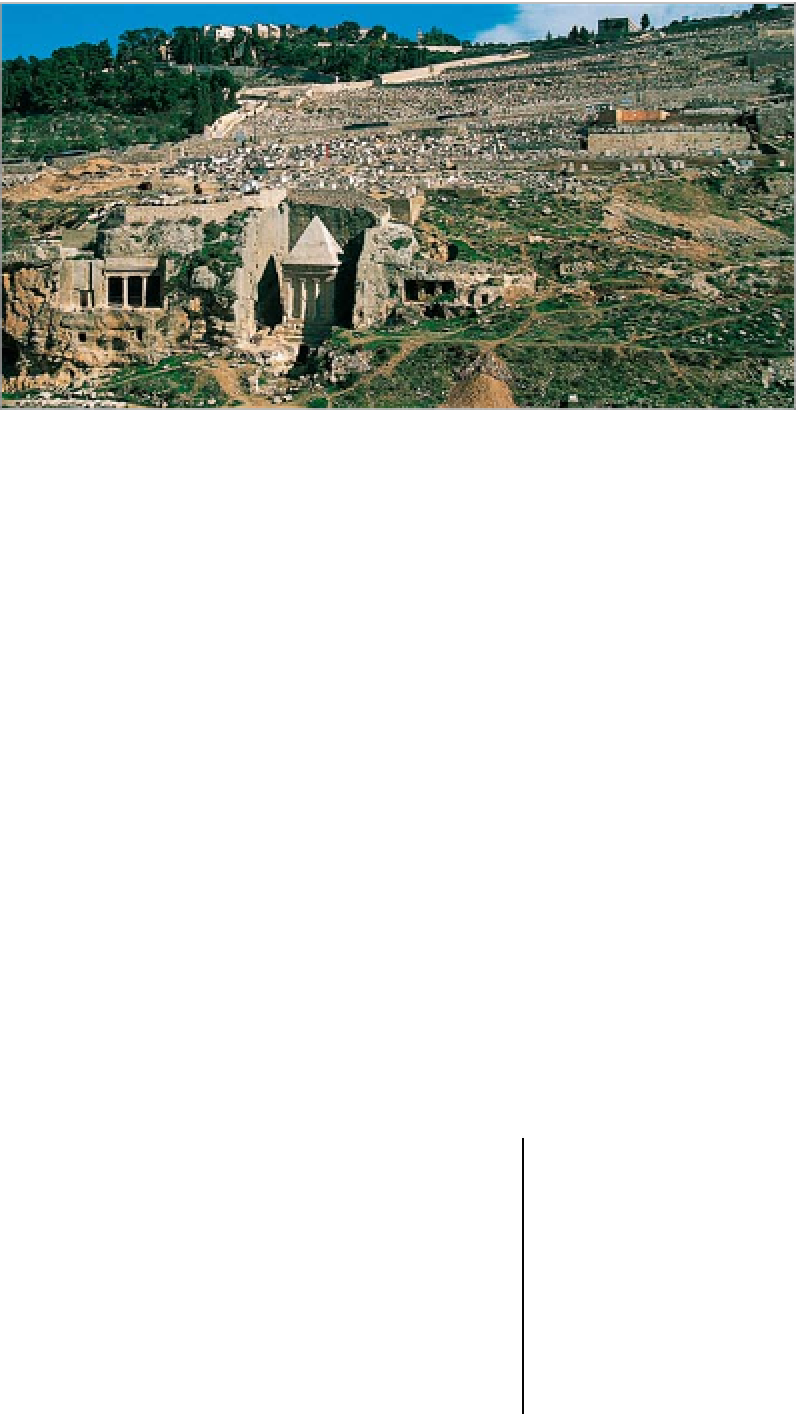
The Tomb of Bnei Hezir (left) and the pyramid-roofed Tomb of Zechariah in the Valley of Jehoshaphat
City of David
0
Maalot Ir David.
Map
2D4
.
Tel
1 800
l
25 24 23.
#
8:30am-5pm (last
entrance: 3pm) Sun-Thu (Shaft &
Tunnel: 4pm in winter), 8:30am-1pm
(last entrance: 11am) Fri.
&
for Shaft
& Tunnel.
8
phone ahead (English-
speaking guides Mon, Wed & Fri).
witness to its transformation
into a place of worship. The
stars on the vaults were
painted in Crusader times.
(330 ft) from the entrance to
the acropolis excavations is
Warren's Shaft
, named after
Charles Warren, its 19th-century
English discoverer. A sloping
A
tunnel, reached by spiral stairs,
leads to the vertical shaft at the
bottom of which is a pool fed
by the Gihon Spring. The
system was built by the Jebu-
sites to ensure a water supply
during sieges. Nearby is their
18th-century BC city wall,
identified by the large, uncut
stone blocks used in its con-
struction. It was sited to bring
the entrance to Warren's Shaft
within the confines of the city.
In the 10th century BC a
tunnel, later attributed to Solo-
mon, was dug to take water
from the Gihon Spring to fields
in the Kidron Valley. In the
face of Assyrian invasion in
about 700 BC, King Hezekiah
had a new tunnel built to bring
the spring water right into the
city, so concealing the source
of the supply.
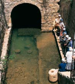
Hezekiah's
Tunnel
ran 533 m (1,750 ft)
from the spring to a large, new
storage pool - the Pool of
Siloam - in the south of the
city. Not far from the Siloam
end an inscription, carved by
the engineer, describes the
tunnel's construction. The
pool is now smaller than it was
originally and was rebuilt after
the Romans sacked Jerusalem
in AD 70 and burnt it “as far as
Siloam”, as told by contempo-
rary historian Flavius Josephus.
Visitors can wade through
the tunnel in thigh-deep water
from the Gihon Spring - wear
shoes and bring a flashlight.
Valley of
Jehoshaphat
9
Map
2 E3.
South of the Temple Mount
(Haram esh-Sharif) a rocky
ridge runs beside the Kidron
Valley. Its summit was already
settled by the Jebusites, a
Canaanite
(see p41)
people, in
the 20th century BC, making
this the oldest part of Jerusa-
lem. It was from them that
David supposedly took the
city for his capital in about
1000 BC (2 Samuel 5: 6-17).
On the site are remains of
buildings up to the city's cap-
ture by the Babylonians in
586 BC. They include 13th-cen-
tury BC walls belonging to the
Jebusite acropolis, fragments
of a palace attributed to David,
and houses burnt in the Baby-
lonian attack. About 100 m
The Kidron Valley separates
the Old City from the Mount
of Olives. Near Gethsemane
the valley is also known by its
Old Testament name, the
Valley of Jehoshaphat (mean-
ing “Yahweh judges”,
Y Yahweh
Y
being the Hebrew name for
God), where it was believed
the dead would be resurrec-
ted on the Day of Judgment
(
( oel 3: 1-17). For this reason,
the valley sides are densely
covered with Christian, Jewish
and Muslim cemeteries.
At the southern end are sev-
eral Jewish rock-hewn tombs
of the 1st and 2nd centuries
BC. Four are particularly fine.
Absalom's Tomb, like an in-
verted funnel, was ascribed in
medieval times to King David's
rebellious son, Absalom. The
so-called Tomb of Jehoshaphat
(the 9th-century BC King of
Judah) behind it has a carved
frieze above the doorway.
The pyramid-topped Tomb of
Zechariah is actually the above-
ground monument of the ad-
jacent Tomb of Bnei Hezir. The
latter has a rectangular opening
with two Doric columns and
was identified by an inscrip-
tion referring to the “sons of
Hezir”, a Jewish priestly family.
The Pool of Siloam, which stored
the City of David's water supply