Travel Reference
In-Depth Information
u
Cafayate
Road
map
B1. 140 miles (225 km) NW
of Tucumán.
*
12,000.
@
n
San
Martín 26, (03868) 422-442/422-223.
_
Folk Festival (Mar).
∑
turismosalta.gov.ar
Considered one of the prettiest
towns in Argentina, Cafayate is a
natural stopover for anyone
touring the Valles Calchaquíes
or traveling between Quilmes,
Tucumán, and Salta. Cafayate
was settled at the beginning of
the 18th century by Franciscan
missionaries. They made use of
the two rivers passing through,
Río Chuschas and Río Loro
Huasi, to create indigenous
farming reserves. Cafayate was
officially founded in 1840, and
soon after, a number of
bodegas
were established on the slopes
that rise gradually around the
edges of town.
With the tranquil ambience of
a village, Cafayate today has
restaurants, museums, and a
few colonial mansions.
Southwest of the main plaza is
Museo Arqueológico Rodolfo
Bravo
, whose ceramic and urn
displays tell the story of the
area's native inhabitants. The
nearby
Museo de la Vid y del
Vino
displays a variety of wine-
related relics.
The vineyards of Cafayate are
exceptional, the grandest being
Finca La Rosa. Now the
Patios
de Cafayate Hotel y Spa
, La
Rosa was established in 1892.
Surrounded by vineyards and
geraniums and rose bushes, this
colonial-style ranch is a classic
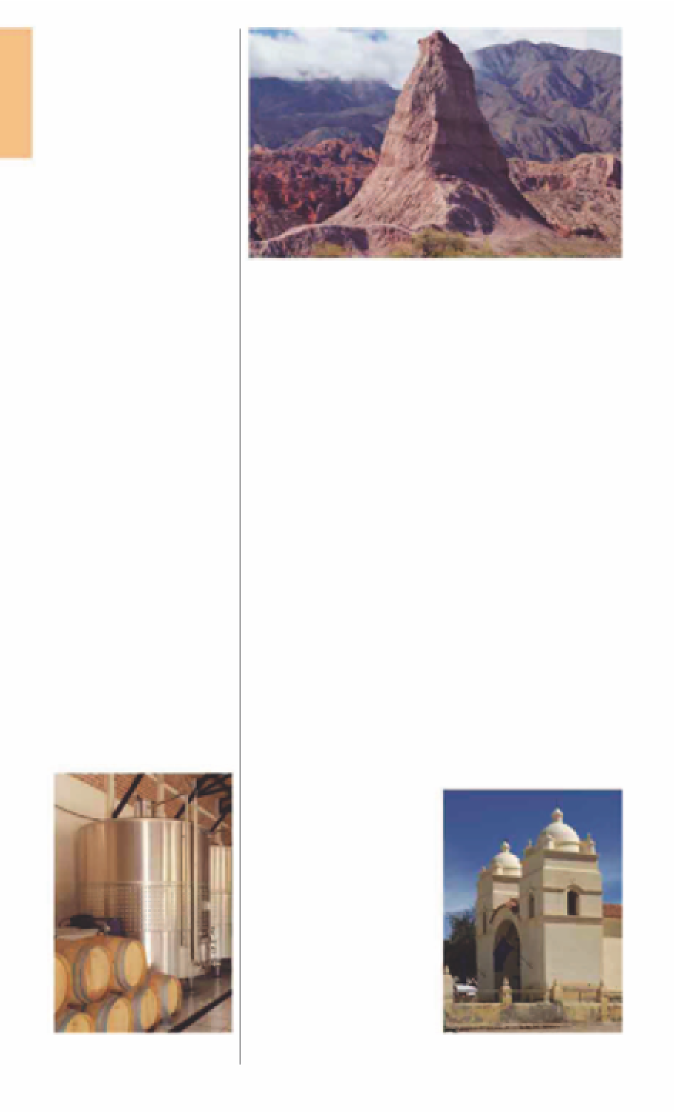
The huge monolith El Obelisco at Quebrada de las Conchas
Argentinian aristocratic estancia.
It also has a wine-themed spa
and a stylish swimming pool.
Ruta Nacional 68 runs through
this ravine, connecting Cafayate
with Salta. Along the route, locals
sell handicrafts, such as ceramics.
E
Museo Arqueológico Rodolfo
Bravo
Colón 191.
Te l
(03868) 421-054.
Open
11am-7pm daily (worth calling ahead).
E
Museo de la Vid y del Vino
Ave Güemes s/n.
Open
10am-7:30pm
Tue-Sun & hols.
&
∑
museodelavidyelvino.gov.ar
Patios de Cafayate Hotel y Spa
RN 40 & RN 68, Salta.
Te l
(03868) 422-
229.
∑
patiosdecafayate.com
o
Molinos
Road
map
B1. 155 miles (250 km) N
of Cafayate.
*
4,000.
@
_
Virgin of
the Candelaria (Feb).
Founded in the mid-17th
century, Molinos (Mills) was a
feudal estate producing corn-
flour, wheatflour, alfalfa, peppers,
and wine until Argentinian
Independence in 1816. Most
visitors only pass through this
remote hamlet on a drive
through the Valles Calchaquiés.
However, the town's colonial,
18th-century
Iglesia San Pedro
Nolasco de Molinos
is well
worth a visit. A small preserve
nearby gives protection to
native
vicuña
.
The dramatic landscape of
cactus-clad slopes around the
town is ideal for riding and
trekking. Around 6 miles (10 km)
i
Quebrada de las
Conchas
Road
map
B1. 12 miles (20 km) N of
Cafayate.
@
The Quebrada de Humahuaca
(see pp200-4)
wears the UNESCO
World Heritage Site title, but for
many travelers in northwestern
Argentina the red-rock ravine
of Las Conchas (“the shells”) is
just as memorable. The tower-
ing walls of the ravine are an
explosion of scarlet and
crimson, rust, and vermilion.
Río Conchas flows through the
valley floor, but only a narrow
strip of land is fertile.
Wind and storm showers over
the years have led to erosion,
leaving behind surreal rock
formations. Some outstanding
ones have been given
nicknames, such as the gigantic
Los Médanos (The Dunes) and
El Obelisco. A huge ravine on
the east side is known as La
Garganta del Diablo (The Devil's
Throat), while a solitary rock is
named El Sapo (The Toad).
Fermentation tanks in one of Cafayate's
many
bodegas
A Spanish-style parish church built in the
1600s, Molinos
For hotels and restaurants see pp278-83 and pp288-99