Environmental Engineering Reference
In-Depth Information
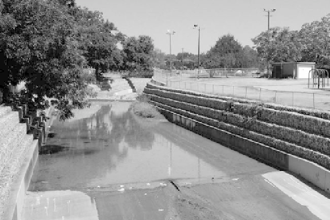
Figure 4.7
The channelized portion of Boggy Creek in East Austin.
An environmental activist familiar with East Austin hydrology makes
a more explicit connection between the channelized East Austin creeks
and social and political conditions of the city:
In West Austin, we have big parks, big rights-of-way for creeks. In East Austin,
we have some parks, those are areas that you know about. But if you start to
walk Fort Branch or Little Walnut, you'll go by many creeks where the width of
the right of way is maybe 50 to 100 feet. And so to get that fl ood fl ow down that
right-of-way, you're not going to have a natural meandering channel, you're going
to line it with a concrete trapezoidal channel and it's going to be dead. And that's
just a matter of when the developer came in, how much right-of-way did the city
make him dedicate to the drainage easement? And yes, that does refl ect the price
of the lot and the price of the house. But it doesn't matter which comes fi rst: it just
is a fact that the public resources are not as nice on the poorer side of our town.
65
From an East Austin perspective, the SGI can be interpreted as another
in a long line of municipal policies to dump the city's problems on East
Austin residents. In this case, the problem was not a matter of undesir-
able minority residents or industrial activities but rather how to balance
the municipality's competing interests of encouraging economic growth
while satisfying the desires of environmental activists to steer this growth
away from the Hill Country. East Austin became the most logical target
for future population growth of the city.
Search WWH ::

Custom Search