Geography Reference
In-Depth Information
this chapter. The optical techniques for mapping ripar-
ian vegetation on floodplains are, for the most part, the
same techniques used to map vegetation, regardless of
setting. These methods are extensively discussed in many
text books, articles, and on-line sources and are already
widely used for resource management (for overviews see
Dieck and Robinson, 2004; Jensen, 2007). In contrast,
techniques specifically focused on the active channel are
sufficiently new that they are not yet widely known to the
management community.
Evaluating whether to use remote sensing requires
knowing which river features can be measured, mapped,
and/or modeled in this manner. The first part of this
chapter therefore reviews active channel features that
can be mapped with passive optical imagery, the general
nature of the remote mapping techniques, and some of
the limitations specific to each application. A subsequent
section summarises issues that are common to many
remote sensing applications (e.g., accuracy assessment).
The chapter concludes with a discussion of factors to
consider when determining whether or not to use remote
sensing rather than, or in addition to, other available
techniques.
Finally, the focus throughout the chapter is on param-
eters that can be monitored and mapped using remote
sensing. These mapping applications may be an end-
point in their own right, but are often just the starting
point for management applications related to model-
ing, planning, and active intervention in the stream. We
briefly mention some management applications such as
habitat assessment and flood planning, but for the most
part we encourage the reader to think about, and imag-
ine, the many uses to which the remote sensing-based
measurement and maps can be put.
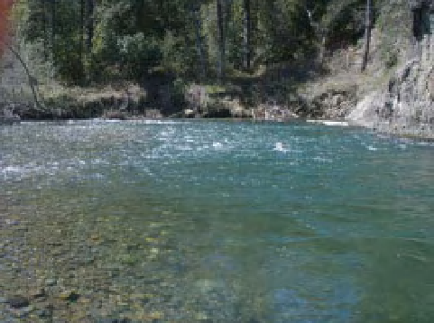
Figure 2.1
Variations in depth (and other river features) can be
easily detected with the naked eye. In this example along the
Trinity River, California, variations in depth are immediately
apparent as variations in water darkness. Likewise, glides, riffles
and pools (i.e. biotypes) can be distinguished by variations in
depth and surface turbulence, and variations in sediment size
are apparent in the shallow water portions of the stream. River
features that are visible to the naked eye are features that, in
theory, can be measured and mapped with optical
remote sensing.
or on the bed). In Figure 2.1, for example, one can gauge
which areas are deeper by the darkness of the water.
Likewise, the human eye can easily pick out variations
in sediment size, pieces of wood, algae on rock surfaces,
surface turbulence, and so forth. All of these are there-
fore good candidates for mapping via remote sensing.
In addition, multi- or hyperspectral data might be able
to pick out more subtle variations in turbidity, depth,
and turbulence.
Alas, life is rarely so simple. Our eyes and brains pro-
cess a remarkable amount of information on the fly:
brightness, colour, texture, shape, shadow, size, spatial
context, rate of movement, and so on. In contrast, remote
sensing algorithms typically use just one, or maybe two
of these factors at a given time. Often, therefore, a remote
sensing-based, image processing approach misses the sub-
tle identifying characteristics that are readily detected by
the human brain. What can be 'seen' with remote sensing
therefore often differs in subtle ways from what the eye-
brain combination can detect. Yet sometimes the different
perspectives provided by remote sensing (especially with
multispectral and hyperspectral imagery) coupled with
trained users can detect more than the brain-eye combi-
nation can see (e.g., Legleiter and Goodchild, 2005).
Much of the previous research on remote sensing of
rivers has focused on using imagery to map the same
2.2 What can be mapped with optical
imagery?
What can you measure and map with optical images? At
one level, the answer to this question is simple: anything
you can see with the naked eye is potentially 'mappable'
with optical imagery. But the answer does not stop there;
hyperspectral and multispectral imagery can detect fea-
tures at resolutions and wavelengths not visible to the
human eye. When looking at a clear-water stream, one
therefore can intuitively determine which features might
be mappable with remote sensing (muddy streams where
the bottom cannot be seen are generally poor candidates
for remote sensing of features within the water column


Search WWH ::

Custom Search