Geography Reference
In-Depth Information
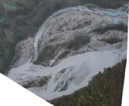
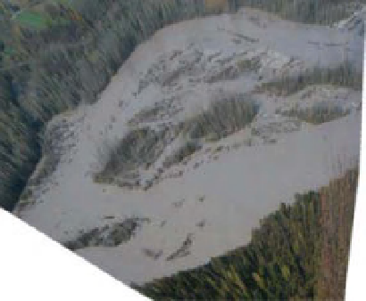
Figure 15.10
Two examples of orthorectified images of the Flagogna reach on the Tagliamento River (flow is from right to left). Flow
levels at the Villuzza hydrometric station are 1.2 m and 2.25 m respectively.
shows two examples of the Flagogna reach at medium
and high flow.
Georectified images have been manually digitised to
produce maps of the water bodies, differentiating between
fully connected channels, upstream disconnected chan-
nels and ponds. A wide range of flows, between minimum
and bankfull levels has been examined, and this is entirely
due to the use of the automated photograph acquisition.
Figure 15.11 reports the results of the analysis, as a func-
tion of the water level measured at the Villuzza gauge
station, 3 km downstream of the Flagogna reach. A clear
relationship exists between the occupation of the braid
plain by water and the river stage. Figure 15.11a shows the
two reaches are characterised by a similar trend, with the
wetted proportion linearly increasing from 10% of the
braid plain width up to 90% at a water level correspond-
ing to approximately a return period of two to three years.
The island braided Flagogna reach is more likely to have
a lower wetted percentage than the Cornino reach, par-
ticularly at higher flow levels and in spite of the narrower
braid plain. This is due to the larger presence of vegetated
patches that force the water into a smaller number of
deeper branches in the Flagogna reach. A large difference
is highlighted by the braiding index, i.e. the average num-
ber of branches in a cross section (Figure 15.11b). The
braiding index peaks in both cases at a water level ranging
between 1 and 1.5 m at the Villuzza gauge, but reaching
an average maximum of 7 at Cornino, whereas in most
cases no more than four branches are observed at the
Flagogna reach. Braiding index then decreases toward 1
for a water level approaching 2.5 m.
Finally,
branches, backwaters), as an indicator of slow flow
habitats. The proportion of disconnected channels is
up to 20% at low flow, but rapidly decreases when the
flow level increases up to 1.5 m (see Figure 15.11c).
The two sites have a slightly different behaviour, with
the Flagogna reach showing a larger proportion of
disconnected water bodies. The presence of vegetation
induces more complex bed topography, with larger
scours and deposits, and therefore a greater possibility to
find disconnected branches up to a water stage of 2 m,
which represents a return period of roughly one year.
This fraction of wet habitat is particularly significant,
because it represents possible refugia for most aquatic
species, particularly during moderate flow pulses. These
water bodies are characterised by completely different
temperature conditions, ensuring warmer (ponds), or
colder (groundwater fed branches) spots that greatly
enhance habitat diversity.
15.4.5 River icedynamics
The study of river ice dynamics remains a difficult task
because of the dangerous nature of the processes involved
and their strong dependence on hydro-meteorological
conditions. It is, for example, difficult to obtain direct
measurement of river ice freeze-up or break-up because
of the fragility of the ice cover at those periods but
also because of the destructive nature of the moving ice
blocks. As a result and in spite of several advances in
fluvial ice studies (Buffin-Belanger and Bergeron, 2011),
some key questions still remain. The use of close-range
photographic time series has helped the investigation of
some of these questions.
we
measured
the
proportion
of
upstream
disconnected
water
bodies
(ponds,
groundwater
fed
Search WWH ::

Custom Search