Geography Reference
In-Depth Information
(a)
Individual (axe F1 et F2 : 91, 20%)
Basalt_1
Limestone_2
Granit_2
Schist_4
Sandstone_3
50
8
45
6
40
4
BA
CA
GR
Sc
GE
35
2
0
30
−
2
25
−
−
20
15
−
10
−
8
−
6
−
4
−
2
0
2
4
6
8
200
400
600
800
1000
1200
-- axe F1 (63, 26 %) -->
Wavelength (nm)
(b)
(c)
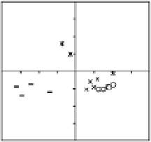
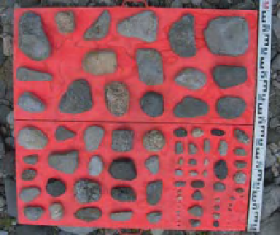
Figure 15.8
a) example of pebble samples obtained along the Ouveze River, France for petrographic characterisation. On the left the
initial sampling plate, on the right, the same set with a petrographic code on each of the particles (Unpublished data, Aloy, 2005)
(CA
Sandstone). b) Result of the discriminant analysis performed on
24 particles showing the first factorial map with a clear distinction of the petrography according to the % of reflectance calculated on
23 wavelength classes from 300 to 1100 nm. c) Example of wavelength signature of five pebbles, each having a different petrography
(Unpublished results, J. Riquier, 2009).
=
limestone, GR
=
Granits, BA
=
Basalt, SC
=
Schist, CR
=
15.4.3 Surveyof subaerial bankprocesses
a picture every 60 minutes, from September to April to
include the autumn, the winter and the spring periods.
The photographic time series provided important infor-
mation on several subaerial river bank erosion processes:
their date and hour of occurrence (during daylight),
their location on the bank and their relative magnitude.
Erosion processes (rock falls, gully erosion, small scale
debris flows) were documented by directly observing the
process on a picture or were inferred from observed dif-
ferences between successive pictures. Process locations
were identified by overlaying a grid onto the photographs
that defined the upper, the middle and the lower bank.
Magnitude was evaluated using a visual appraisal of the
spatial extent of each event. Figure 15.9b-d illustrates
the time series of the key parameters for three subaerial
processes that were extracted from the photographs. The
The lower part of the Ouelle River in Quebec, Canada is a
highly sinuous sandy river that is prone to intense gravel
aggradation downstream from a slope change delimiting
the meandering sandy section from a wandering gravel
river reach. Recently, an intensification of the frequency
at which the river bed has to be dredged to protect a
highway bridge has increased. There is no indication of
increasing discharge in recent years, so attention has been
focused on the frequency and magnitude of subaerial
processes (Couper and Maddock, 2001) that affect several
eroding banks in the wandering reach of the Ouelle River
(Hamel, 2011). To document the nature and the chronol-
ogy of subaerial processes affecting one of these banks
(Figure 15.9a), a Reconyx camera was deployed to capture


Search WWH ::

Custom Search