Geography Reference
In-Depth Information
(a)
(c)
(b)
(d)
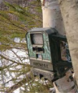
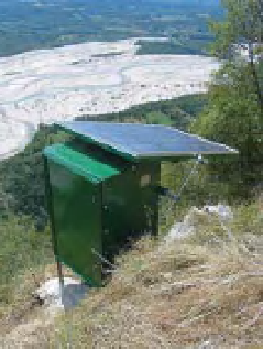
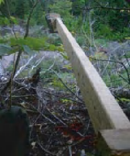
Figure 15.1
(a) and (b) The acquisition system on Monte Prat, overlooking the Tagliamento River, Italy; (c) a Reconyx camera
installed on a tree on the Ouelle River and (d) a sliding arm holding a Reconyx Camera allowing it to overlook an eroding bank on
the Ste-Pierre River, Quebec.
2012, for more details). The aim is to survey the river
configuration with a high temporal resolution, in order to
investigate relationships between water, sediments, and
vegetation processes at the scale of single flood events.
Each monitoring system is composed of a digital reflex
camera, with an 18 mm lens and a 6M pixel CCD sensor
and pictures are acquired every hour during daylight. The
choice of a wide angle lens has the advantage of increas-
ing the extent of the area photographed, but at the cost
of reduced spatial resolution. Given the distance of the
camera to the river (1 km on average, ranging between
0.5 and 1.5 km), the ground pixel size is approximately
25-50 cm. Electric power is supplied by a photovoltaic
solar panel, with two 12V batteries to guarantee a regular
charge for up to four cloudy days. Specifically designed
software allows full control of the camera, with the pos-
sibility to setup the desired acquisition time interval, and
to store the pictures. The cameras were installed in 2008
and until the autumn of 2011, more than 10 flow pulses
or floods were observed, with peak levels ranging from
the threshold for sediment movement to bankfull. The
temporal accuracy and the large range of discharge condi-
tions allow the investigation of several geomorphological
and hydrological processes at the reach scale (e.g. Bertoldi
et al., 2010; Welber et al., 2012) and permit investigation
of local processes such as bank erosion, tree transport and
bifurcation evolution.
It would be relatively straightforward to equip each of
these sites with two cameras so that stereo pairs could be
acquired, which would enable extraction of a Digital Ele-
vation Model using photogrammetric procedures. Build-
ing on the work carried out by Lane et al. (1994; 1996),
Chandler et al. (2002) used an automatic procedure of
DEM extraction applied to digital stereo images of a 125 m
long reach of the Sunwapta river, Canada. The monitor-
ing setup proposed by Chandler et al. (2002) consisted
of three digital reflex camera stations, with a resolution
of 6 MB, positioned 125 m above the river channel. The
survey produced daily orthophotographs and DEMs with
each pixel providing ground coverage of approximately
5
5 cm, which made possible the analysis of mor-
phological changes on the temporal scale of a single flood
event with a high spatial resolution. This procedure needs
a limited amount of ground data, but requires high image
resolution to automatically recognise homologous points
on the stereo images.
Recently, low cost digital cameras able to capture time
lapse or triggered pictures have been developed by the
hunting industry. These cameras are designed to capture
the presence of animals when they wander in front of
the camera. There are now several companies and models
available on the market (Table 15.1). The cameras are
generally mounted with a trigger sensor and an infrared
flash to provide oblique or vertical scenes. The motion
sensor triggers the camera when a movement occurs in
the detection range and a series of pictures is taken at a
predetermined frequency and number of repetitions. The
infrared flash allows the acquisition of pictures at night
for events occurring in the foreground. Some cameras
allow capture of short videos. One such camera used
by Buffin-Belanger in Quebec, is the Reconyx Hyperfire
with a 2048 by 1536 pixels resolution. Ground reso-
lution varies according to the distance of the camera
to the area of interest. For example, at a distance of
.
5
×
2
.

Search WWH ::

Custom Search