Geography Reference
In-Depth Information
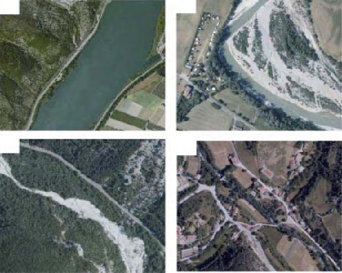
(a)
(b)
(c)
(d)
Figure 11.13
Examples of problems limiting the analysis of fluvial corridor features at a corridor to network scale (a) deep water
preventing in-channel feature detection, (b) riparian canopy hiding in-channel features or providing shadow, (c) overlightening
reducing the radiometric variation between water and gravel bars, (d) channel too narrow to be detected. Data from BD ORTHO
R
of the IGN,
©
IGN - France.
taken: (i) only the portion of the image covering the valley
corridor as identified from a DEM analysis was extracted,
(ii) within this corridor, the basic polygons (water, gravel,
natural vegetation) were detected by an object-oriented
procedure considering radiometry and channel size.
investment, it can provide a significant source of data
for multiple purposes, thereby allowing the development
of risk assessment and prospective approaches based
on various what-if scenarios. Biophysical information is
needed to assess human pressures and impacts, develop
predictive biological response models, identify riparian
buffers that link physics and water chemistry, target con-
servation strategies, and plan restoration activities that
link flood risk assessment and ecological improvement.
Following this technological revolution, scientists
and managers are also facing questions related to data
management and data sharing. It is clear that imagery
web-platforms and online remote sensing data provide
an opportunity to extract almost real-time information
regarding biophysical change. Channel response to
restoration measures will then be accessible to all from
the web, allowing for improved linkage between public
expectations and management actions.
11.6 Conclusions
As in the 1960s, when major investments led to a new-
found abundance of monitoring data related to water
quality, river managers are faced with managing and eval-
uating new data describing the biophysical state of river
corridors and incorporating the new data in the decision
making process. This is particularly true under the new
regulatory pressure of the WFD in Europe.
Moreover, it is now acknowledged that point-based
typologies, such as RHS (River Habitat Survey) in the
UK, are limited because they cannot easily detect lon-
gitudinal thresholds and discontinuities or downstream
propagation of channel change. They should thus be com-
plemented by continuous spatial information such as pro-
vided by images. While the development of a continuous
description
Acknowledgements
The authors would like to thank the water agency RMC
for its support to the ZABR research group within the
of
the
channel
corridor
is
an
important


Search WWH ::

Custom Search