Geography Reference
In-Depth Information
Spatial
disaggregation
Spatial
aggregation
(a)
UGO
1
UGO
2
UGO
3
UGO(i,j)
DGO(i,j,k)
AGO(i,j,k)
Attributary table
Attributary table
Attributary table
id
_River
id
_River
Rank
_
UGO
id
_River
Rank
_
UGO Rank
_
DGO
Rank
_
UGO Rank
_
DGO
i
j-1
i
i
j
j
j
k-1
k
i
i
j
j
j
k-1
k
k
+
1
i
j
i
j
+
1
i
k
+
1
i
Linear referencing axis
Confluences
(b)
(c)
UGO
1
DGO
1
's nodes
45556
Rank of DGO
1
44562
DGO
3
Channel stream power (Watt.m
-1
)
0 - 250
44552
250 - 500
500 - 700
750 - 1000
1000 - 1500
1500 - 2500
2500 - 4000
4000 - 6000
6000 - 10000
10000 - 125000
44550
44556
44554
44548
44560
44558
UGO
1
263
UGO
2
's LRA
262
DGO
3
264
Rank of DGO
3
UGO
2
261
259
258
254
253
252
251 250
Subwatersheds
Gauging stations
255
249
256
248
257
DGO
3
DGO
4
(2001)
DGO
4
(2006)
DGO
5
Eroded area
UGO
4
's LRA
N
0
50
100 kms
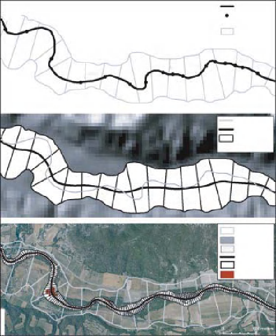
Figure 11.6
Examples illustrating the process of disaggregation and aggregation: a) Theoretical framework with associated tables, b)
Geographical objects resulting from the disaggregation procedure established on the Dr ome river, France: Elementary channel length
shared at each inflexion point (DGO1), elementary floodplain segments (DGO3), elementary channel segments (DGO4) for 2001
and 2006 years, showing also eroded areas during the studied period, c) mapping of AGO channel stream power for biennal discharge
at the Rh one network scale (40 000 km). Modified from Alber, A. and Piegay, H. Spatial disaggregation and aggregation procedures
for characterizing fluvial features at the network-scale: Application to the Rh one basin (France). Geomorphology, 125(3), 343-360.
Copyright 2011, with permission from Elsevier.


Search WWH ::

Custom Search