Geography Reference
In-Depth Information
(a)
(f)
Mature woodland
1
2
3
Channel
Surrounding landscape
3
1
Bar (sediment)
Riparian vegetation
4
Wood deposit
150 m
1000 m
Salix alba
(b)
(d)
(g)
Populus nigra,
Fraxinus excelsior
3
3
1
Pioneer vegetation
2
Phragmites australis
Former gravel mining pit
1
Cultivated area
1
150 m
40 m
400 m
2
Surrounding landscape
(c)
(e)
(h)
3
2
1
2
4
2
3
Surrounding landscape
1
Individual pioneer trees
colonising gravel bar
100 m
500 m
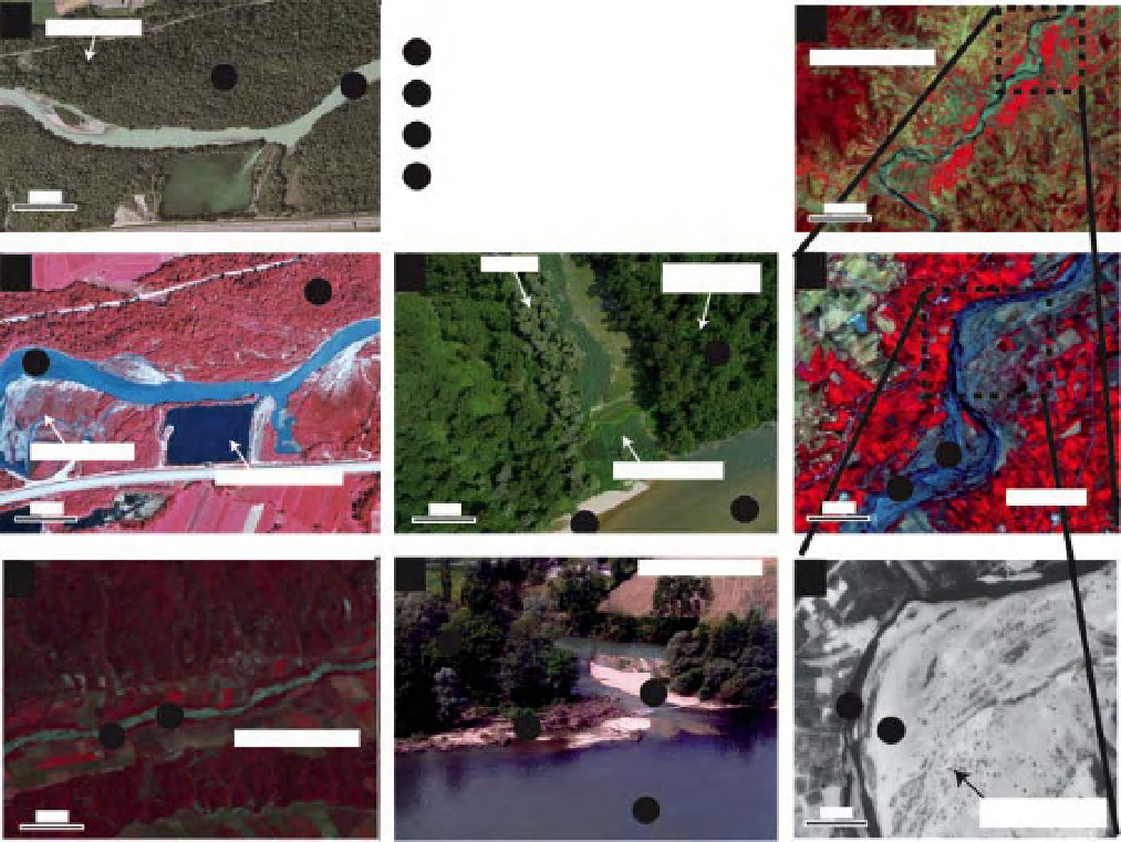
Figure 10.1
Various examples of images, a) Commercial aerial photo of the Arve River (France, 2000), true colour, spatial
resolution
0.5 m, produced by the French
Institut Geographique National
(IGN), b) Aerial photo of the same site as image a. but in
1984, and with infrared colour spectral resolution. Source: French Institut National de l'Information Geographique et Forestiere
(IGN), c) Landsat ETM
=
30 m, composition with bands 2, 3 and 4. NASA
Landsat Program, USGS, Sioux Falls, d) Very high resolution picture taken from an unmanned aerial vehicle (UAV), Ain River
(France), spatial resolution
=
0.05 m. © CNRS, e) Oblique picture of the Ain River (France), done by helicopter in summer 1991.
©
+
image, June 2002, Asse River (France), spatial resolution
=
image,
June 2002, spatial resolution
=
30 m, composition with bands 2, 3 and 4. NASA Landsat Program, USGS, Sioux Falls; g) Spot 5
image, August 2008, spatial resolution
CNRS, (f), (g) and (h). Three images of the same site (Laou River, Morocco) with different resolutions: f) landsat ETM
+
10 m, composition with bands 2, 3 and 4. Cnes 1986-2010, Distribution Spot Image and
h) GeoEye image summer 2011, spatial resolution
=
0.5 m (from Google Earth
©
=
site).
software. Thus, image analysis and remote sensing tools
have been widely used for resource management (Belward
and Valenzuela, 1991), and vegetation studies (Walsh
et al., 1994; Alexander and Millington, 2000), notably
in forested ecosystems (Iverson et al., 1989; Boyd and
Danson, 2005) and wetlands (Lehman and Lachavanne,
1997; Ozesmi and Bauer, 2002; Adam et al., 2010). They
have also been used in fluvial geomorphology (Gilvear
& Bryant, 2003) and for the characterisation of riparian
vegetation (Muller, 1997; Goetz, 2006; Yang, 2007).
In this chapter, we review how imagery can be used for
the description and analysis of the structure and dynamics
of riparian vegetation. It is neither an exhaustive overview
nor a technical catalogue, but rather an application-
oriented synthesis. We also discuss the limitations that
can strongly reduce the efficiency of these tools; despite
the vast amount of raw data collected on riparian vegeta-
tion, current methods only partly cover the information
required by both researchers and river managers. Indeed,
if from a technical point of view the range of the potential
Search WWH ::

Custom Search