Geography Reference
In-Depth Information
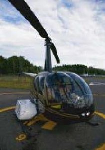
(a)
(b)
(c)
Figure 9.13
Photographs of helicopter-based image acquisition system. a) Helipod attached to helicopter. b) Interior of the helipod
containing the imaging system. c) FLIR SC660 (thermal) and Canon EOS 550D mounted on pan-tilt.
(a)
(b)
Figure 9.14
a) Optical (3 cm spatial resolution) and b). Thermal infrared (TIR) (20 cm spatial resolution) imagery of the same
section of the Milnikek river in the Gaspesie region (Quebec, Canada). On the TIR image, the darker blue section on the right
corresponds to a cold thermal anomaly created by the input of a small groundwater fed tributary.
the Matapedia River (Quebec, Canada) and of all its
tributaries accessible to Atlantic salmon (Figure 9.14).
This work demonstrates that producing spatially
continuous maps of fluvial habitat over entire riverscapes
is now at hand.
measurement of velocity fields from helicopter-based
imagery is possible by stabilising the images from the
moving helicopter using known coordinates of fixed
points on the image. Although the possibility of repeating
this procedure at several contiguous locations along the
river seems feasible, no one has yet attempted to do so.
Another potential avenue which shows promise is along-
track interferometric SAR from high resolution satellite
platforms. Romeiser et al. (2007) have demonstrated that
TerraSAR-X data can be used to calculate surface veloci-
ties for large to medium rivers. The TerraSAR-X satellite
is a synthetic aperture radar sensor/platform. Romeiser
et al. (2007) use a Doppler effect in order to deduce sur-
face flow velocity. Since TerraSAR-X data has a spatial
resolution of 3m, this method cannot be applied to rivers
less than a few tens of meters wide.
An alternative approach which was made possible by
Geosalar innovations is the direct estimation of flow
velocities based on known discharge and image-based
9.6 Flow velocity: mapping or
modelling?
While flow velocity constitutes one of the most important
fluvial habitat variables, its measurement at riverscape
scale probably represents the major remaining challenge
in terms of habitat mapping. Although large-scale par-
ticle image velocimetry (LSPIV) can be used to obtain
detailed surface flow velocity fields from shore-based
video imagery of short river reaches (see Chapter 16),
its application to longer river segment appears imprac-
tical. Fujita and Hino (2003) demonstrated that LSPIV


Search WWH ::

Custom Search