Geography Reference
In-Depth Information
method may outperform manual approaches if no train-
ing data are available even if the parameters associated
with these methods are determined in a non-optimal way.
The results further demonstrate the algorithm's potential
for accurately processing data from different SAR sensors.
Towards a similar aim, Pulvirenti et al. (2011a) propose
a SAR image processing algorithm which maps flood areas
and is to be inserted in the operational flood management
system of the Italian Civil Protection authorities. The
algorithm can be used in an almost automatic mode or in
an interactive mode, depending on the user's needs. Using
also simple hydraulic and contextual information, the
approach is primarily based on fuzzy logic and uses three
different electromagnetic scattering models to retrieve
SAR backscatter information allowing the user to also
deal with more complex situations such as emergent
flooded vegetation. The algorithm is designed to work
with radar data at L, C, and X frequency bands and also
employs ancillary data, such as a land cover map and a
digital elevation model. The flood mapping procedure
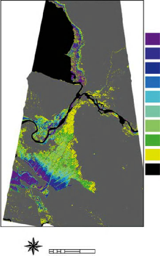
was tested on a flood that occurred in Albania on January
2010 using multi-temporal COSMO-SkyMed very high
resolution X-band SAR data (Figure 6.4).
For fully automated unsupervised flood detection
in large very fine resolution single polarised SAR data
sets (
∼
1-5 m, such as TerraSAR-X scenes), Martinis
et al. (2009, see also Martinis et al., 2011) propose a
split
based
automatic
thresholding
and
classification
Jan. 31, 2010
Jan. 25, 2010
Jan. 24, 2010
Jan. 21, 2010
Jan. 20, 2010
Jan. 19, 2010
Jan. 17, 2010
Jan. 16, 2010
Jan. 10, 2010
permanent water body
19
°
25
′
E
19
°
30
′
E
19
°
35
′
E
N
W
E
0
2
4
6
Km
Map Scale 1:250,000
S
Figure 6.4
Multi-temporal map showing the time evolution of the Shkoder flood in Albania. It has been produced by applying the
algorithm proposed by Pulvirenti et al. (2011a) to nine COSMO-SkyMed images with acquisition dates reported in the legend.
White: no data; gray: non-flooded. Reproduced from Pulvirenti et al. (2011a) An algorithm for operational flood mapping from
Synthetic Aperture Radar (SAR) data using fuzzy logic. Nat. Hazards Earth Syst. Sci., 11, 529-540.
Search WWH ::

Custom Search