Environmental Engineering Reference
In-Depth Information
a
100
ge3500m (20 Pct FS Threshold)
2009
2008
2007
2006
2005
2004
2003
2002
2001
2000
80
60
40
20
0
80
100
120
140
Day of Year
160
180
200
220
b
3000 to 3500m (20 Pct FS Threshold)
100
2009
2008
2007
2006
2005
2004
2003
2002
2001
2000
80
60
40
20
0
80
100
120
140
Day of Year
160
180
200
220
c
2500 to 3000m (20 Pct FS Threshold)
100
2009
2008
2007
2006
2005
2004
2003
2002
2001
2000
80
60
40
20
0
80
100
120
140
Day of Year
160
180
200
220
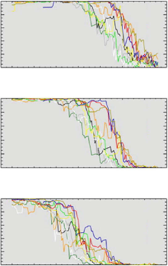
Fig. 3.9
Snow cover results from MODIS depletion of snow cover over several years. The curves
are derived from the MODIS cloud-gap-filled (CGP) 500 m resolution product derived from the
fractional snow cover product, MOD10A1, in the Wind River Range, Wyoming. Breaks are
evident in the plots in some years due to sporadic mission MODIS data. (
a
) Elevation greater
than or equal to 3,500 m; (
b
) Elevation from 3,000 to 3,500 m; (
c
) Elevation from 2,500 to 3,000 m
(Figure 2 in Hall et al.
2012
)
Search WWH ::

Custom Search