Environmental Engineering Reference
In-Depth Information
Wavelength (µm)
14.3
300
13.3
12.5
11.8
11.1
10.5
10
9.52
9.09
8.7
8.33
8
300
280
280
260
260
240
240
GOES-08 Imager
GOES-12 Imager
220
220
200
20
700
750
800
850
900
950
1000
1050
1100
1150
1200
1250
7.69
7.14
6.67
6.25
5.88
5.56
5.26
4.17
4
3.85
3.7
300
300
300
300
280
280
280
280
260
260
260
260
240
240
240
240
220
220
220
220
200
200
200
200
1300
1400
1500
1600
1700
1800
1900
2400
2500
2600
2700
Wavenumber (cm
-1
)
Wavenumber (cm
-1
)
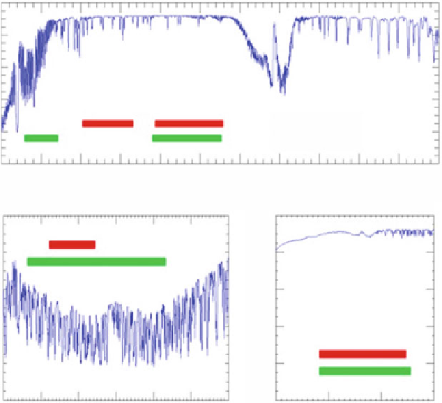
Fig. 19.2
Spectral distribution of the GOES-8 and GOES-12 imager channels
such as the total precipitable water and the characteristics of the middle-infrared
channel of 3.9
m to correct for atmospheric effects.
The land surface temperature can be produced for each cloud-free land pixel
observed by the GOES sensor. The spectral characters of GOES-12 through 15
imager are listed in Table
19.1
.
μ
19.3 Theoretical Description
The GOES-LST algorithm development is based on a scientific research conducted
by Sun and Pinker (
2004
) and Yu et al. (
2008
,
2009a
,
b
,
c
). Theoretical details of the
research are provided in this section.
Search WWH ::

Custom Search