Environmental Engineering Reference
In-Depth Information
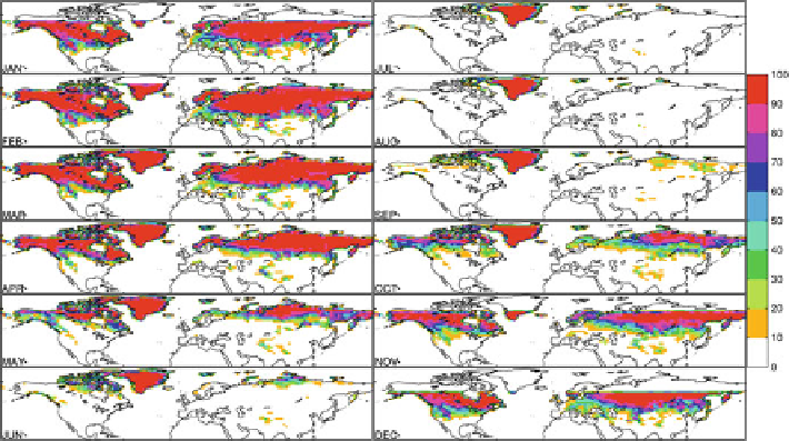
Fig. 12.1
Shows The MODIS-monitored Northern Hemisphere snow-cover fraction (SCF, %)
from January to December. Note that during winter, there are some blank areas in high-latitude
region due to the polar night
(roughly 25-45
N), begins to build up shallow snow cover in October due to its
high elevation. During the snow maximum (the end of February), more than half of
the North American continent and a large portion of Eurasia are covered by snow
(SCF larger than 90%). The transition zone of the snow line (edge) reaches
approximately 50
N. Tibet and the Rocky Mountains are two noteworthy snow
regions in the middle latitudes. From March to August, the snow cover gradually
depletes toward the North Pole due to the increase in solar energy. The moving of
the snow line is generally parallel with the latitude lines, except in mountainous
regions where there exists some patchy scattered snow at high elevations.
It is still difficult to obtain a complete, accurate global SWE dataset only based
on in situ observations, due to limited observational stations with SWE
measurements, as described earlier. Passive microwave remote sensing, such as
SSMR-SMM/I (Chang et al.
1987
) and AMSR-E (Chang and Rango
2000
), could
provide snow water estimation with relative larger errors. In the future, data
assimilation incorporated with land surface models has proved to provide the best
estimation of SWE by optimally merging observation and model information to
minimize potential errors (Pan et al.
2003
; Rodell et al.
2004
).
12.3 Snow-Climate Interaction
Observational studies have demonstrated that regional-scale snow-cover anomalies
are strongly linked with many large-scale general circulation anomalies, such as
summer monsoon onset and intensity (Bamzai and Shukla
1999
), lagged changes in
Search WWH ::

Custom Search