Environmental Engineering Reference
In-Depth Information
on the Loess Plateau demonstrate that 40% vegetation cover may reduce the soil erosion by 62%, and
54% vegetation cover may reduce erosion by 80% (Li and Zhang, 1997). A study indicates that the soil
erosion the Loess Plateau is inversely proportional to the density of the vegetation cover. The sediment
yield reduces to nearly zero if the forest cover is higher than 60% (Wang and Wang, 1999).
Estimating rate of erosion with vegetation
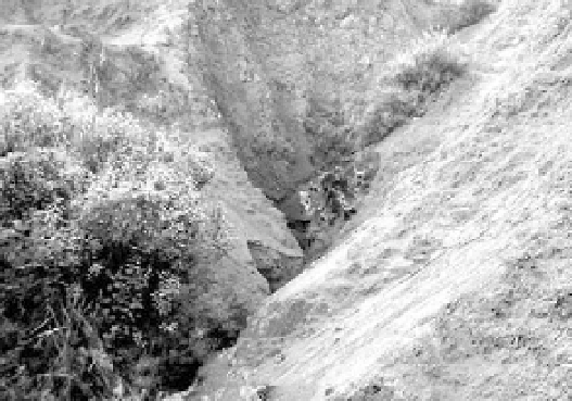
—Vegetation may be used for estimation of the erosion
rate. Rill and gully erosion are the main patterns of upland erosion. It is estimated that more than 60% of
sediment yield results from rill and gully erosion. The rate of rill and gully erosion can be estimated by
the following method: select newly eroded rills or gullies on slopes with vegetation, as shown in Fig. 2.24.
The trees on the banks of the gully are very useful for the erosion estimation. Tree-ring sampling is
performed to estimate the age of plants on the gully banks and the depth of the gully erosion is measured
directly from the tree elevation to the gully bed. The rate of the gully erosion may be calculated by dividing
the depth of the gully by the age of the plants. This method is based on the assumption that vegetation and
rills or gullies develop on the slope simultaneously, and the plants grow up while the rills and gullies erode.
Fig. 2.24
Trees on the gully banks used to estimate the rate of gully erosion (See color figure at the end of this topic)
Modeling of vegetation development
—Many efforts have been made to model vegetation dynamics.
Svirezhev (1999) studied the development of vegetation patterns (grass or forest) under climatic and
anthropogenic stresses. Three fundamentally different approaches to the solution of the problem have
been proposed. The first one is based on the assumption that climatic factors such as temperature,
precipitation, etc., are the factors which best define the allocation of different plant communities around
the world. The approach has been used to investigate the geographical distribution of the main biomes
under prospective climatic changes at a global scale (Monserud et al., 1993). The second approach is
based on the description of physiological growth processes and their dependence on local climatic
parameters, and it mainly operates with the global carbon cycle. The third approach is an attempt to
apply dynamic models using either mathematical ecology or mathematical evolutionary genetics.
Introducing
p
(
x
,
y
,
t
) and
q
(
x
,
y
,
t
) =1-
p
to represent the probabilities of the vegetation pattern being forest
and grass, respectively, Svirezhev (1999) presented a simple model to calculate the probability of the
vegetation of an area being grass or forest.
Maley and Brenac (1998) analyzed the pollen record from the Lake Barombi Mbo and found that the
vegetation is naturally dynamic with pollen concentration varying from 1,000-50,000 per gram of deposit
following climate change and other stresses. Pedersen (1998) introduced a conceptual model of the process
of tree mortality responding to ecological stresses. To simulate short and long-term stresses the model

Search WWH ::

Custom Search