Environmental Engineering Reference
In-Depth Information
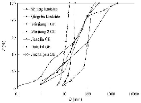
Grain erosion has occurred mainly in granite, limestone, and metamorphic rocks. The grains produced
due to grain erosion in the limestone area was relatively coarse with diameter between 10-200 mm, grains
in the granite area were finer with diameter between 5-30 mm; while in the metamorphic rock area the
grain diameter varied in a large range from 0.1-300 mm. Figure 2.14 shows the size distributions of grain
erosion deposits from the Minjiang River (granite rock), Jiuzhai Creek (limestone), and Xiaojiang River
(phyllite rocks), in which GE represents grain erosion. Minjiang 1 and Minjiang 2 are two grain erosion
sites along the Minjiang River near Wenchuan. Jiangjia and Dabaini Ravines are two tributaries of the
Xiaojiang River. As a comparison the size distributions of landslides on the Shiting and Qingzhu Rivers,
which are not far from Mianyang, are shown in the figure as well. The two landslides were triggered by
the Wenchuan earthquake and caused thousands of casualties. The range of the size distributions of solid
particles in the landslide deposits has 6 orders of magnitude from 0.01 mm to 10 m, whereas the grain
erosion deposit has diameters within 2 orders of magnitude for granite and limestone and 3 orders of
magnitude for metamorphic rocks. Relatively uniform grain size and lack of large stones are common
features of grain erosion which is much different from those of landslides and avalanches.
Fig. 2.14
Size distributions of grain erosion deposits (GE represents grain erosion)
Exposure to weathering is the main agent for grain erosion, which may be proved by the following
phenomena. The rocks on the Minjiang River became bare after the avalanches on May 12, 2008 triggered
by the earthquake. Until early March 2009, grain erosion along the Minjiang River occurred only at
several sites with limited areas. From March to June, the Minjiang River experienced the strongest sun
exposure and driest season. During this time grain erosion developed very quickly with the area of grain
erosion almost doubled. In general, the grain erosion on the south-facing bank of rivers is much more
intense than that on the north-facing bank. Figure 2.15 shows the grain erosion on the south-facing bank
and rill erosion (water erosion) on the north-facing bank of the Chaqing Gully along the Xiaojiang River.
The lithology (phyllite) and rainfall on the two banks are the same but the sun exposure on the north-facing
bank is much weaker than on the south-facing bank, therefore, grain erosion occurs on the south-facing
bank and water erosion occurs on the north-facing bank. These phenomena prove that sun exposure
weathering is the most important agent for grain erosion.
Shattering erosion is mainly caused by freeze-thaw cycles and has very different characteristics. It was
found that north-facing slopes have more intense erosion than south-facing slopes in semiarid northeastern
Arizona canyons (Burnett et al, 2000; Halsey et al, 1998).

Search WWH ::

Custom Search