Environmental Engineering Reference
In-Depth Information
NR
Z
Z
:
(11.6)
B
LL
Z
1
(11.7)
Z
1
L
(11.8)
According to Horton's law the ratios
R
B
,
R
A
,
and
R
L
are invariant with stream order and network
structure. In other words, Horton's ratios are the same for different rivers and for different stream orders.
Nevertheless, scientists doubt the universality of Horton's law. For instance, (Kirchner, 1993) argued that
Horton's ratios may be not constant for different stream networks. Liu and Wang (2008) studied Horton's
ratios for different rivers and found that the Horton's ratios are constant only for the stream orders higher
than 8, or for rivers with a length over a thousand kilometers. For lower stream orders Horton's ratios
vary with the stream order and are very different for different river networks.
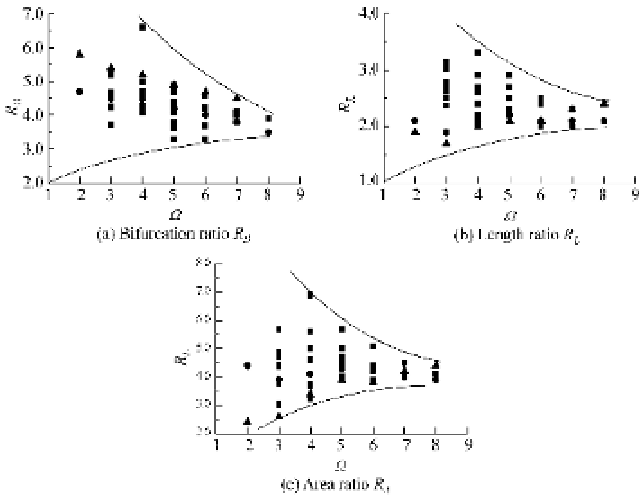
Figure 11.20 shows the relations between Horton's ratios and stream order, in which the data were
collected from Stankiewicz (2005) and Chinese rivers (Liu and Wang, 2008). For stream orders lower
than 5, Hoton's ratios are very different for different rivers. Nevertheless, all Horton's ratios converge
with increasing stream order. The bifurcation ratio, length ratio, and area ratio converge to 4, 2, and 4 for
a stream order of 8, respectively. The law of 4-2-4 seems to be true only all drainage networks of high
stream orders.
AR
Z
1
A
Z
1
A
Fig. 11.20
Horton's ratios for :-order stream networks (
Ƶ
data from Stankiewicz (2005);
Ʒ
the Yanhe River;
ƽ
the
Nuoming River both from Liu and Wang (2008))
For low stream orders Horton's ratios greatly vary. Howard (1967) classified stream networks into
several types: Trellis network, Parallel network, and Radial network. Nevertheless, the classification
sometimes divides networks with similar drainage structures into different categories. Also, this kind of
classification lacks quantitative descriptions. Liu and Wang (2008) classified river networks into: plume
network, vein network and dentritic network. They used GoogleEarth as the main data source, which
provides global satellite images at varying resolutions by adjusting the “eye altitude” parameter. In their
study the “eye altitude” was fixed for all data analysis. Thus, all data were collected in the same resolution.

Search WWH ::

Custom Search