Environmental Engineering Reference
In-Depth Information
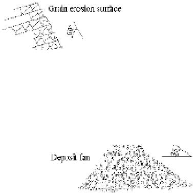
In general a grain erosion site consists of three parts: grain erosion surface at the top, grain flow
section in the middle, and a deposit fan at the toe of the slope, as shown in Fig. 2.10 (Wang et al., 2009b).
The rock surface of grain erosion has a slope angle in the range of 45°-60°. There is no vegetation on the
erosion surface. The detached particles roll or flow through a section, which has a slope angle of about 40°.
The deposit fan has an angle of about 35°, which is equal to the angle of repose of the granular material.
In the grain flow section the particles rolled and jumped down the slope. At each step a particle hit
against the slope material, thus, the grain flow scoured the slope to form a channel. The channel has an
angle of about 40° and the channel bed consists of relatively uniform sediment. Occasionally, particles
fall onto the grain flow section from the grain erosion surface and initiate numerous particles rolling and
saltating along the “path”. Sometimes a layer of grains flows down the section, during which most of the
particles slide and roll. The grain flow cuts the slope and forms a flume-like granular movement path.
Figure 2.11(a) shows a 2 m deep channel of a grain flow section on the bank of the Xiaobaini Ravine
(a tributary of the Xiaojiang River), which is about 50 m long with a slope of 42°. Figure 2.11(b) shows
several grain erosion sites along the Minjiang River near Wenchuan. Avalanches induced by the Wenchuan
Earthquake have left many bare rocks along the Minjiang River. Intensive grain erosion has been occurring,
especially in the dry season from March to June in 2009. The grains are much finer than the avalanche
deposit. A part of the grain erosion deposit has been carried away by the river flow. Figure 2.11(c) shows
a grain erosion site on the north bank of the upper Jiangjia Ravine, which provided a lot of loose solid
material for debris flows. Figure 2.11(d) shows the vegetation damaged by grain erosion and grain flow
along Jiuzhai Creek, which is a famous tourist attraction because of its beautiful landscape and vegetation.
The grain flow section is 800 m long. The lithology consists of limestone and the grains generated from
the erosion have a mean diameter of about 10 cm. The grains jump down the slope and hit against the
trees. Most trees on the grain flow path have been killed.
Fig. 2.10
Schematic diagram of a grain erosion site
Grain erosion has caused flying stones that have injured humans. Most of the highways in western
Sichuan province are constructed along rivers. People have repaired or reconstructed highways that were
damaged or destroyed by the earthquake. All highways were reopened before the one year anniversary of
the Wenchuan earthquake. Nevertheless, due to the continual grain erosion, particles with a diameter from
1 cm to 20 cm roll and saltate down the slope potentially falling on cars and humans. The authors of this
paper have witnessed that the windshield of a car was broken and the driver was seriously injured by a flying
stone. Grain erosion has caused many highways to become so called “flying stone sections”, especially


Search WWH ::

Custom Search