Environmental Engineering Reference
In-Depth Information
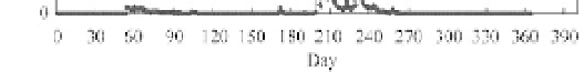
Fig. 8.10
Discharge hydrograph of Shahe River in 1963
8.2
Flooding Risk and Flood Defence Strategies
Large river deltas and coastal areas are densely populated and highly industrialized. Therefore, flooding
risk and flood defense is an important issue for estuary management. Flooding risk,
R
, may be expressed
as a function of flooding probability
P
f
and the number of people and value of properties threatened by a
possible flood,
N
v
, i.e.
(8.1)
The flooding risk is very high in large river delta because both
P
f
and
N
v
are higher than other areas in
the watershed. Flooding threat in large river delta is due to
ķ
subsidence of the land, which is created
by sedimentation from the river;
ĸ
tsunamis, hurricanes and storm surges; and
Ĺ
heavy rainstorm. The
flooding risk and flood defence strategies are discussed with the Venice Lagoon, Indian Ocean Tsunami,
Kartrina and New Olean, and Hong Kong as examples.
RPN
f
v
8.2.1
Flooding Due to Subsidence—Venice Lagoon
Venice Lagoon has 550 km
2
of surface area and is the largest wetland of the Mediterranean, as shown in
Fig. 8.11. It is divided from the sea by a strip of barrier islands, that runs for about 60 km from the mouth
of the Adige to the mouth of the Piave, interrupted by the lagoon inlets of Lido (800 m wide), Malamocco
(400m wide ) and Chioggia (380 m wide). Inside the lagoon basin are Venice, Chioggia, Murano, Burano
Torcello and more than 50 islands; about 70 km
2
of salt marsh (low-lying areas which are covered with
halophytic vegetation); a 1,580 km network of canals that ensures the propagation of the tidal currents up
to the boundary with the mainland. In the northern and south-central lagoon, the lagoon boundary is defined
by fish farms (areas that take up a surface area of about 90 km
2
, are separated from the living lagoon and
are equipped for fish farming). The average depth of the lagoon is 1.2 m.
The present drainage basin of Venice Lagoon has an area of about 2000 km
2
that pours about 2.8
million m
3
of water a day into the lagoon. The drainage basin has a total of nearly 1.5 million inhabitants.
The northern Adriatic governs the lagoon ecosystem with its tides that enter and exit the lagoon twice a
day through the lagoon inlets, reaching two maximums and two minimums (semidiurnal tides). It has
been calculated that the volume of water exchanged daily between the sea and the lagoon is about 400
million m
3
. The average range of tide heights in the lagoon is about 0.7 m. Nevertheless, the tidal level is
subject to important variations, above all in relation to astronomical and meteorological factors.
In the history, rivers, including the Po River, carried sediment into the lagoon and resulted in a problem
of sedimentation. In the 14-19 centuries, the rivers were deflected into the Adriatic bypassing the lagoon,
which almost completely eliminated the “refurnishment” of sand and sediment from the hinterland. The


Search WWH ::

Custom Search