Environmental Engineering Reference
In-Depth Information
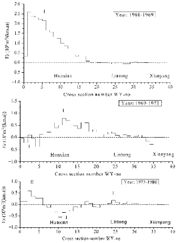
axis is the number of the measurement cross-sections on the Weihe River; the average distance between
the neighboring cross-sections is about 6 km. In the period from 1960 to 1969, Tongguan's Elevation
rose abruptly from 323.5 to 328.5 m (see Fig. 6.45). As a result, sedimentation occurred in the reach
around Huaxian at a rate of up to 2.5 million tons per km per year (Fig. 6.47a). The mark “I” indicates
that the sedimentation corresponding to the first ascending period of Tongguan's Elevation. In the period
from 1969 to 1973, the sedimentation wave moved upward to the reach between Huaxian and Lintong,
but the rate of sedimentation decreased to about 0.75 million tons per km per year (Fig. 6.47b). In the
meantime the first erosion wave occurred near the river mouth, which corresponded to the first
descending period of Tongguan's Elevation, indicated by the mark “1”. In 1973-1980 the first
sedimentation wave had moved upstream to Lintong, the first erosion wave had moved to Huaxian, and
the peaks had obviously decreased too. During this period, the second sedimentation wave occurred in
the reach between the river mouth and Huaxian, indicated by the mark “II”. This wave of sedimentation
Fig. 6.47
Erosion (-) and sedimentation (+) per unit length per year showing retrogressive waves in the lower
Weihe River, as a result of ascending and descending of Tongguan's Elevation. (The cross-sections are numbered
from the river mouth. Huaxian, Lintong, and Xianyang are hydrological stations by the river and are about 50 km,
128 km and 180 km upstream from Tongguan. The distance between neighboring cross-sections is about 6 km.)

Search WWH ::

Custom Search