Environmental Engineering Reference
In-Depth Information
turbulent floods, the main channel is silted up at high rate, 0.1-0.2 m/yr. Now the river bed is 6-10 m
higher than the surrounding ground and is named the “suspended river”. In many sections the main
channel was flattened and was at the same elevation as the floodplain, therefore, the 1996 flood did not
flow down the river in a well-defined channel but flowed randomly within an up to 10 km wide valley
confined by the Grand Levees. In many sections the flow was directed to the levee and causing levee to
burst. The propagation speed of the flood wave was much lower than normal, thus, the 1996 flood took
17 days to travel the 800 km from Huayuankou to Lijin although the average time for floods of the same
discharge in 1950-1990 was only 7-8 days.
6.4.3 Water Diversion Causes Flow Cut-Off
The Yellow River watershed is a semi-arid area and the river is the main water resource for 150-200
million people in the middle and lower reaches. With the booming economy, demand for water has
rapidly increased. Water diversion in the middle and lower reaches of the Yellow River has escalated.
Because of the serious water shortages and the absence of a workable plan for distributing the valuable
water to various provinces and regions, all localities on both banks of the river try to store and use water
as much as they can. Not only low concentration water is diverted during the non-flood season, but also
the high concentration flow in the flood season is diverted. As a result, less and less water is released to
the lower reaches. The annual runoff and sediment load at Lijin (110 km from the river mouth) is shown
in Figure 6.16. The annual water flow before 1985 was 40 billion m
3
but reduced to only 15 billion m
3
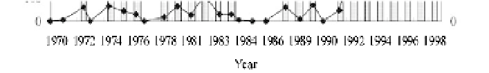
after 1985. Figure 6.26 shows the days and length of dried-up channels of the lower Yellow River from
1970 to 1998. In 1972, the Lijin Station in Shandong Province recorded a 15 day period when the river
dried up. For the first time in known history, the mother river stopped flowing. The river suffered two
major droughts, one from 1875-1878 and another from 1922 to 1932 without drying out, but it began to
dry out in the 1970s. Flow cut-offs have occurred in 19 of 27 years in the period 1972-1998.
Fig. 6.26
Dry days and dry length of the lower Yellow River from 1972-1998
Before 1990, the drying out often took place in May and June. But after 1990, the drying up started
early in February, and ended as late as October. In 1970s, the river only dried for about 10-20 days and
the dry section was only 135 km long. The river remained dry for 80 days in 1994, 122 days in 1995, 133
days in 1996 and 226 days in 1997 and the dry section stretched to 700 km from the river mouth. The
river flow was cut off in flood season because the floodwater was diverted for irrigation and drinking.
Figure 6.27 shows that the river flow cut off and the dry river bed in the flood season in 1977. Boats
were resting on the bed and the floating bridge was not so useful because vehicles may drive across the


Search WWH ::

Custom Search