Environmental Engineering Reference
In-Depth Information
dredged to the lee side of the levee. Nevertheless, after the first flood in the year the dredged section was
basically filled up by sediment deposition. Figure 6.19 shows 2 cross sections of the dredged reach. The
cross sections were resilted after only one flood. The perspective of dredging the river channel as a
general solution for channel sedimentation is not rather optimistic.
(a) (b)
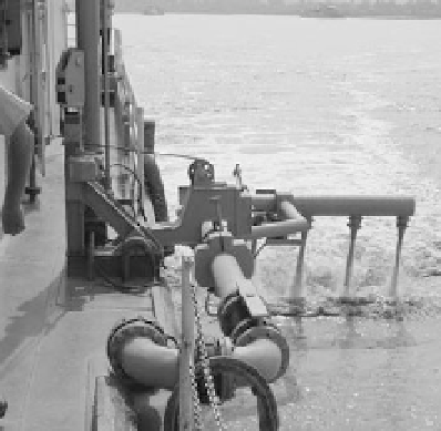
Fig. 6.18
Two types of agitating jet dredgers scouring sediment during flood season
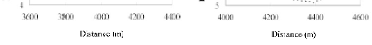
Fig. 6.19
Resiltation of the dredged sections after the first flood in 1998: (a) Wuqizha cross section; (b) Shibahu
Cross section ( ŷŷ Original bed, ƒƒƒƒƒƒƒ Dredged ŷżŷ After the first flood)
6.3
Water Resources Management
6.3.1 General Conditions
The average precipitation on the Yellow River basin is 476 mm but the potential evaporation is
1,000-3,000 mm per year. The total runoff from the watershed is 58 billion m
3
, about 2% of the total of
the country. There is ground water of about 40.2 billion m
3
in the area but it must be recharged with
surface water and rain water. Water resources per capita is 590 m
3
and the water resource per farmland is
4,850 m
3
/ha. Moreover, the neighboring areas, such as the Haihe River basin and the Huaihe River basin,
also divert water from the Yellow River because the two areas also suffer from water shortage and the
lower Yellow River is higher than the surrounding ground and can be directly diverted to these areas. For
instance, Tianjin has been supplied Yellow River water almost every year since the end of the 1990s. To
supply 600 million m
3
of water more than 2 billion m
3
must be diverted from the Weishan water Diversion
Station because more than 70% of the diverted water is consumed and diverted on the way from Weishan
to Tianjin.


Search WWH ::

Custom Search