Environmental Engineering Reference
In-Depth Information
past 70 years. Sunkou is a typical cross section in the lower Yellow River, which is not very wide and not
narrow and is located at the middle of the lower reaches of the river.
Fig. 6.2
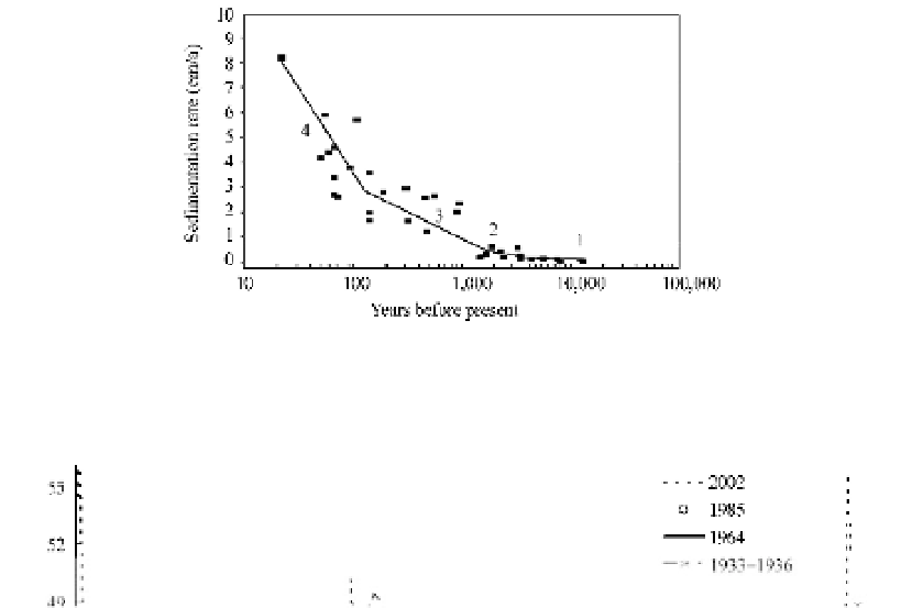
Sedimentation rate in the lower Yellow River during the 4 historical periods: 1) geological sedimentation;
2) sedimentation due to climate change; 3) sedimentation due to human activities; 4) accelerated sedimentation due
to human activities (after Xu 1998)
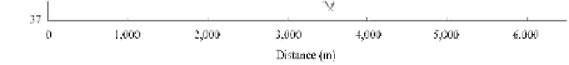
Fig. 6.3
Sedimentation caused changes in the riverbed at the Sunkou cross section during the period 1933-2002
(Sunkou is 300 km downstream from Zhengzhou and 440 km upstream from the river mouth)
Over time, a perched river formed that frequently breached its levees. From 602BC to 1949AD the
river experienced 1,593 levee bursts, flooding vast areas in 543 years and claiming millions of human
lives. The river shifted its major course (600-700 km long) by avulsion 26 times with the apex around
Zhengzhou resulting in devastating calamities and numerous old channels, including 8 major shifts
(5 natural and 3 human-caused) with the river mouth alternating between the Bohai Sea and the Yellow
Sea. Because of its wild behavior, the lower Yellow River was dubbed “the sorrow of China”. The 700 km
long lower reaches have swept throughout the north China plain and left numerous old channels. Figure 6.4
shows the migration of the river from 602BC to 1855AD and the old channels and the land created by
the river.
The most disastrous floods are briefly summarized as follows: (WUHEE and IWHR, 1985)
1117
—A high flood occurred in the lower Yellow River due to heavy rainfall and the river levee was
breached at many places. More than one million people were killed by the flood.


Search WWH ::

Custom Search