Environmental Engineering Reference
In-Depth Information
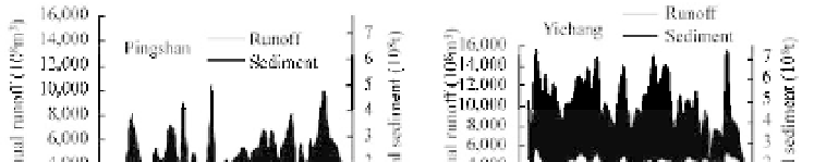
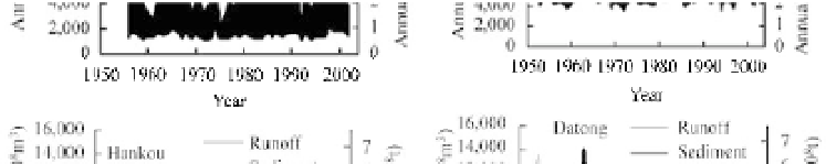
Fig. 5.58
Water-sediment charts of four main hydrological stations along the main course of the Yangtze River
From Yichang to Hankou, flow curve rises but the sediment curve decreases, which means a lot of sediment
deposits in the reach between Yichang and Hankou. From Hankou to Datong, sediment load increases
little but flow increases. The black area becomes very small and gray areas show up. Especially from
1980 to 2003, the sediment curve reduces below the flow curve and the black area changes into a gray area,
which implies a trend of sediment reduction. The estuary is changing from a sedimentation area into an
erosion area.
5.4.4 River Sediment Matrix
The river sediment matrix is composed of 3
u
3 components. The first row of the matrix represents
sediment yield area—usually the upstream watershed, the second row means sediment transportation
reaches—the river channel, and the third row stands for the sedimentation area—usually the delta and the
estuary. The first column is sediment erosion from the local area, the second column means sediment
transportation from upstream reaches, and the third column indicates sedimentation in the area.
For the Yellow River, the Loess Plateau is the main sediment yield area, therefore, the first row means
the Loess Plateau, the second row represents the reach from Sanmenxia to Lijin, and the third row
implies the sedimentation area in the estuary including the Yellow River delta and the river downstream
from Lijin. Equation (5.79) is the Yellow River sediment matrix:
2.2
0.1
0.7
§
·
¨
¸
A
¨
0.1
1.6
0.7
(5.79)
¸
Yellow
¨
¸
0.0
1.0
0.8
©
¹
in which all the values are annual sediment amount in billion tons. The first row indicates that the annual
sediment yield from the Loess Plateau is 2.2 billion tons, 0.1 billion tons of sediment are transported into
the river from upstream areas, and 0.7 billion tons are deposited in the area. The second row shows that
sediment erosion from the riverbed and banks in the reach between the Sanmenxia Dam and Lijin is 0.1
billion tons, 1.6 billion tons of sediment are transported into the reach from upstream reaches and 0.7
billion tons of sediment deposit in this reach. The third row shows that 1.0 billion tons of sediment are
transported to Lijin from the lower reaches of the river and 0.8 billion tons of sediment are deposited in


Search WWH ::

Custom Search