Environmental Engineering Reference
In-Depth Information
along the course and the hydrograph becomes flatter as flow propagates downstream. For hyperconcentrated
floods, however, the crest discharge may increase along the course and the hydrograph may become steeper.
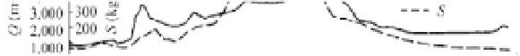
Figure 5.42 shows the hydrographs of a hyperconcentrated flood at the Xiaolangdi, Huayuankou, and
Jiahetan stations in August 1982. The crest discharge at the Xiaolangdi station was 4,570 m
3
/s, but increased
to 6,260 m
3
/s at the Huayuankou station, and then reduced to 4,530 m
3
/s at the Jiahetan station. The inflow
between the Xiaolangdi and the Huayuankou stations was only 100 m
3
/s.
Fig. 5.42
(a) Hydrographs and sediment graphs of a hyperconcentrated flood at the Xiaolangdi, Huayuankou, and
Jiahetan stations in August 1982
Enlargement of the crest discharge of the flood wave may be caused by
ķ
inflow from tributaries
between the two stations;
ĸ
scoured sediment from the channel increasing the volume of the flood wave;
Ĺ
measurement error; and
ĺ
acceleration of the second flood wave and overlap of discharge of the two
flood waves at the lower station. Generally speaking the measurement error is less than 5% and the
inflow from the tributaries between the Xiaolangdi and Huayuankou stations was only several hundred
cubic meters per second. The concentration at the downstream station was not higher than the concentration
at the upstream station, therefore the enlargement of discharge was not due to scoured sediment. The
enlargement of the peak discharge must be due to the acceleration of the second flood wave and overlap
of the discharge of the two waves. Moreover, if the first flood wave is higher than the bank full discharge
a part of the flood may be detained on the floodplain. The sediment may deposit on the floodplain
because the flow turbulence is not sufficient to offset the fall velocity of the sediment. The floodplain
becomes higher and the detained water becomes clearer, which flows back to the main channel and
causes the higher discharge.
5.3
River Patterns
A channel pattern represents a mode of channel form adjustment in the horizontal plane, which is
additional to but nevertheless linked with transverse and lengthwise modes. It influences flow and can be
regarded as an alternative to slope adjustment when valley slope is treated as constant at short and medium
timescales. The most important patterns of channels of alluvial rivers are meandering, braided, straight,
wandering, and anastomosing channels.


Search WWH ::

Custom Search