Environmental Engineering Reference
In-Depth Information
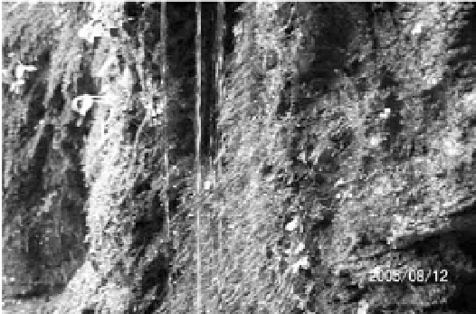
surface of the neighboring hills, ground water flows through rock pores and the channel banks into the river,
as shown in Fig. 1.1. This part of ground water returning to the rivers keeps the stream flow perennial
and relatively stable.
Fig. 1.1
Ground water flows though rock pores and channel banks into the stream (Chexi Creek near the Three Gorges
of the Yangtze River)
If rainfall intensity is less than infiltration capacity, water infiltrates into the soil at a rate equal to the
rate of rainfall. If the rainfall rate exceeds the infiltration capacity, the excess water either is detained in
small depressions on the soil surface or travels down slope as
surface runoff
(Fig. 1.2). Factors that
affect runoff processes include climate, geology, topography, soil characteristics, and vegetation. Average
annual runoff ranges from zero (desert) to more than 1 meter in China. The surface runoff gathers and flows
in streams or rivers, and finally pours into the ocean. Runoff discharge (or discharge) is the volume of
water flowing across a section of the stream per time and usually the unit of discharge is cubic meters per
second (m
3
/s or cms in some literature).
Fig. 1.2
(a) No surface runoff for light rain; (b) Surface runoff occurs when rainfall intensity exceeds the infiltration
capacity
1.1.2
Drainage Network
The drainage network occupies only a small part of a drainage basin, but it has been the subject of great
geomorphic and hydrologic interest, especially since the publication of Robert Horton's paper on drainage
network in 1945. The techniques developed by Horton for quantitative description of a drainage network


Search WWH ::

Custom Search