Environmental Engineering Reference
In-Depth Information
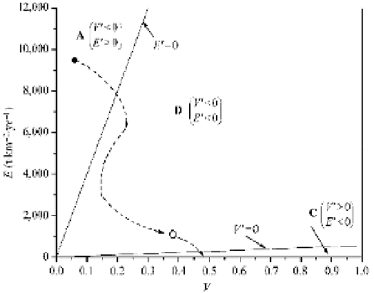
Fig. 2.38
Vegetation-erosion chart for the Anjiagou watershed on the Loess Plateau of China (
ƽ
-before 1956;
ƻ
-in
1988;
ė
route of the vegetation development and erosion reduction) (after Wang et al., 2003b)
the Loess Plateau the most effective way to control erosion is to increase the vegetation cover, to move
the system from the Zone A into the Zone D. Thence the system will move in the direction of erosion
reduction but also vegetation reduction. Humans can further increase the vegetation cover by planting trees
and reduce erosion by engineering strategies. The dashed curve shows the route of watershed management
and vegetation development. Unfortunately, Zone C is too small to stable vegetation development.
Human effort is always needed to maintain a stable or increasing vegetation cover. For the Anjiagou
watershed, although reforestation and erosion control have been continued for more than 30 years, the
rate of erosion has been reduced by 90%, and the vegetation cover has increased by 8 times, the state of the
system still is in Zone D. It is possible for the system to return to Zone A if the vegetation is not carefully
protected. To move the system into Zone C, both reforestation and erosion control must be continued.
From the vegetation-erosion dynamics and the vegetation-erosion chart the following can be concluded.
ķ
Vegetation is affected by various stresses. The stresses can be mathematically expressed, based on
which the coupled differential equations of vegetation-erosion dynamics are established.
ĸ
Four parameters
a
,
c
,
b
,and
f
in the equations are determined using field data and a trial and error method.
Ĺ
The
theoretical solution of the coupled differential equations has been compared with the real development
processes of vegetation and erosion in the Anjiagou watershed on the Loess Plateau and the Xiaojiang
watershed and its sub-watersheds on the Yunnan-Guizhou Plateau. The theoretical curves agree well with
the field measurements of the real processes.
ĺ
Simplifying from the coupled differential equations and
using the four parameters the vegetation-erosion chart can be developed, with which one can predict the
development trend of the vegetation and erosion, and suggest the most effective strategy to permanently
improve the landscape.
Ļ
On the Yunnan-Guizhou Plateau with relatively high precipitation and
temperature, vegetation can develop well if erosion is controlled and the vegetation is stable after
improvement. On the dry and cold Loess Plateau, vegetation can effectively control erosion but erosion
reduction exhibits low effectiveness on vegetation development. Vegetation in the area is not stable and
management is always needed to maintain the vegetation.
In general the vegetation of a watershed or an area may exist in three states, i.e., vegetation-developing
and erosion-reducing, vegetation-deteriorating and erosion-increasing, and the transitional state between
the two. Human activities may change a watershed from one state into another, the effort required depends
on the distance from the present position to the destination position on the vegetation-erosion chart.

Search WWH ::

Custom Search