Geology Reference
In-Depth Information
were recognized: (i) a frost-rubble, or tundra, zone (“frostschuttzone”) lay to the imme-
diately south of the continental ice sheets, (ii) a forest-tundra zone, generally more
restricted in extent, lay south of the treeline and the frost-rubble zone, and (iii) a steppe
zone of open parkland vegetation lay to the east of the treeline and extended as far as the
Ural Mountains in the east and as far south as the northern shore of the Black Sea. Col-
lectively, these three ecozones were thought to represent the extent of the periglacial
domain at that time. Under this reconstruction, much, if not most, of Europe outside of
the continental ice sheets was affected by periglacial conditions at the height of the last
glacial advance. Only the southern parts of the Iberian Peninsula and coastal areas bor-
dering the Mediterranean were thought to have escaped.
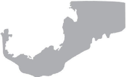
A more specifi c indicator is the former extent of Pleistocene permafrost. The southern
limit can be inferred from the recognition of frost-fi ssure pseudomorphs and casts, and
other structures indicating the former existence of ground ice (Figure 11.12). It is clear
that permafrost was present in a zone across eastern, central, and northwestern Europe.
A wide periglacial belt, approximately 500 km wide in central and eastern Europe,
extended westwards into eastern and central England. The diffi cult, still unresolved,
problems relate to (a) the severity of the periglacial climate, especially the mean January
PLEISTOCENE PERMAFROST
Figure 11.12.
Map of western and central Europe showing southern permafrost limits as proposed
by Poser (1948), Kaiser (1960), Maarleveld (1976), and Velichko (1982). Modifi ed from Vanden-
berghe and Pissart (1993). Numerous other studies, including Dylik (1956), Johnsson (1959), Morgan
(1971), Gozdzik (1973), Karte (1987), Kolstrup (1987), Svensson (1988a) and Eissmann (1994)
document inferred Pleistocene-age permafrost structures in Europe.