Geology Reference
In-Depth Information
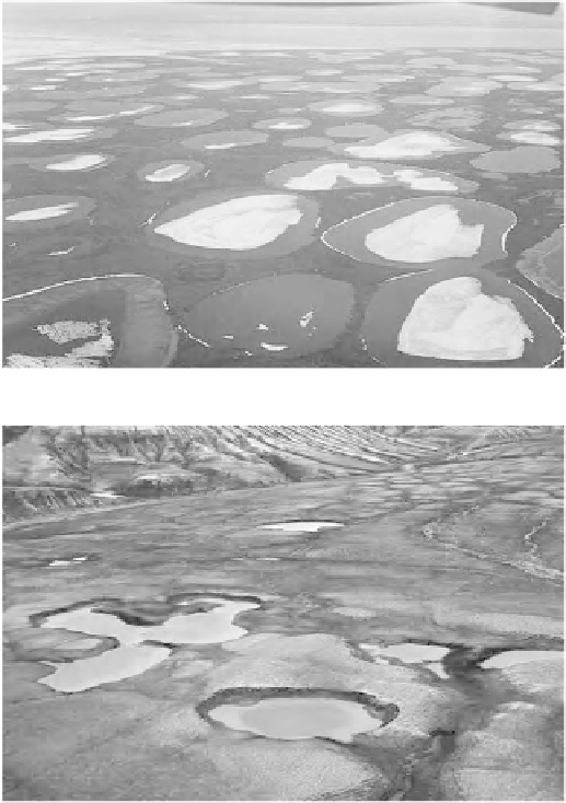
terrain wherever fi ne-grained ice-rich sediments are present (Figure 8.10A). Fluvial ter-
races, outwash plains, coastal areas, and drained-lake basins are favored localities. Typi-
cally, the outline shape of thaw lakes is smooth. Thermokarst ponds may also form in
bedrock, provided it is poorly consolidated, fi ne-grained, and ice-rich (Figure 8.10B).
Intimately associated with thaw lakes are numerous shallow depressions that mark the
existence of previous thaw lakes. Many depressions appear to overlap with each other,
thereby intuitively suggesting a relatively rapid and progressive evolution of thaw lakes
through initiation, expansion, capture, and eventual drainage.
In the North American literature, thaw lakes fi rst attracted attention in northern
Alaska (Hopkins, 1949; Wallace, 1948), where they are variously called tundra lakes, thaw
lakes, thaw depressions, thermokarst lakes, and tundra ponds (Black, 1969).
Like many landforms, the initial cause of a thermokarst depression is problematic. It
may be the quite random melting of ground ice, the subsidence of the ground, and the
(A)
(B)
Figure
8.10.
Thermokarst lakes in northern Canada. (A) Thaw lakes, Baillie Island, Bathurst
Peninsula, western Arctic coastal plain. (B) Thermokarst ponds developed on ice-rich shale of
Cretaceous age, Sabine Peninsula, Eastern Melville Island, High Arctic.