Environmental Engineering Reference
In-Depth Information
(a)
(b)
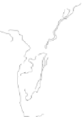
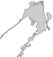
Fig. 11.4
The island-wide survey for supercolonies of the yellow crazy ant
Anoplolepis gracilipes
prior to the aerial campaign of 2002. (a) Supercolony
occurrence at 1024 waypoints spaced at 364 m intervals across the island in
2001. Large dots indicate waypoints with supercolonies of the YCA. The grid
was rotated 27
°
from north to align with the existing network of drill lines. Actual
survey transects at each waypoint were offset 25 m away from the drill line. (b)
Final distribution of supercolonies following detailed boundary delimitation by
ground crews in 2002. Some supercolonies areas discovered during the IWS
were baited by ground crews before the aerial operation, and do not appear
in (b). In both maps, grey areas indicate clearings without forest cover, mostly
abandoned phosphate mining areas. Contours are indicated at 50 m intervals.