Travel Reference
In-Depth Information
one that's erupting in one manner or another every single day. Several of Suwanosejima's
more recent dramatic seismic activities were in November 2008, when multiple explosions
created ash plumes that rose 1.25 miles (2.4 kilometers) into the sky; and in October 2009,
when a magnitude 6.9 earthquake occurred 34 miles (55 kilometers) southeast of the island.
The island's largest recorded historical eruption took place in 1813-14, when it had to be
completely evacuated. It remained unpopulated for the next 70 years.
7
AKUSEKIJIMA
悪石島
Akusekijima (
悪石島
; Akuséki-jima; lit. “Evil Stone Island”) is the fifth and final inhabited is-
land in this northern cluster of the Tokararettō. If you let your imagination run a bit wild, you
might say that the shape of this small island is that of a headless, armless and legless torso. It's
a little over 1 mile (2 kilometers) across from east to west, and about 2 miles (3 kilometers)
from north to south. Altogether, it has an area of 3 square miles (7 square kilometers) and a
circumference a bit more than 8 miles (13 kilometers). You'd have to run around the island's
perimeter more than three times to complete a marathon. And that would be dangerous as
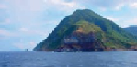
Akuseki Island is encircled by steep cliffs. As is the case with most of the Tokara Islands, there
are no beaches on Akusekijima.
The port at Akuseki forms a small bay.
Akuseki is surrounded by steep cliffs.
The island's port is built into a natural inside elbow on the center west side of the island,
which, with the addition of tons of sturdy Japanese concrete, forms a small bay. There's no
village there, however. To reach town you travel up the hillside a little less than a mile (1 kilo-