Travel Reference
In-Depth Information
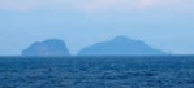
Uninhabited Kogaja (left) and Gaja (right), the two “Lying Down Snake Islands.”
Altogether, Kuchinoshima's area is a little over 5 square miles (13 square kilometers), with
a circumference of a bit over 12 miles (20 kilometers). The Kanji character
口
(
kuchi
) means
“mouth,” a reference to the craters of several good-sized volcanoes on this island: Mt Mae (
前
岳
; Maé-daké), with an elevation of 2,062 feet (628 meters), and Mt Yoko (
横岳
; Yoko-daké)
at 1,647 feet (502 meters). Both are located near the center of the main body of the island.
There's a good circle-island road that goes right around them and there are trails almost to
the very top of both.
2
KOGAJAJIMA
小臥蛇島
This micro-sized uninhabited islet lies about 14 miles (22 kilometers) west of Nakanoshima.
It is egg-shaped, about 1,640 feet (500 meters) wide from east to west and almost a mile
(1.6 kilometers) long from north to south. Its name literally translates as “Little Lying Down
Snake Island,” which doesn't make it sound all that attractive. Maybe that's why it's not in-
habited. Maybe JNTO (the Japan National Tourism Organization) should get to work on this
and rename it, something like “Happy Island” or “Isle of Beauty and Peace.” Why not? Years
ago, the Bahamas renamed “Hog Island” as “Paradise Island” and look what it did for that
place. Neither Kogajajima (
小臥 蛇島
; Ko-gaja-jima) nor Gajajima (
臥蛇島
; Gaja-jima) is in-
habited or inhabitable.
3
GAJAJIMA
臥蛇島
Four miles (6 kilometers) further west from Kogajajima (19 miles/30 kilometers west of
Nakanoshima) is Gajajima (
臥蛇島
; Gajajima) or “Lying Down Snake Island.” It's Little Lying
Down Snake Island's larger big brother is also uninhabited. It's roughly triangular in shape,
less than a mile (1 kilometer) wide and 1.5 miles (2.5 kilometers) long from top to bottom.
Ditto the renaming idea. There's a volcano on the island, Mt Ontake (
御岳
; On-také).
4
NAKANOSHIMA
中之島