Travel Reference
In-Depth Information
there simply is no demand for an inter-island ferry service. Virtually all ferries operate out
of the Ishigaki hub and it's therefore usually necessary to return there before embarking to
another island.
Second, it is 15 miles (24 kilometers) southwest from Ishigaki Port to Aragusuku, but
there is no ferry service in any case. The island's population is variously reported as twelve,
seven, six or even two. Therefore, not only is there is no ferry service, there are no public or
commercial services of any kind on the island, that is, no
minshuku
, convenience stores, gas
station, schools, post office, etc. Those wishing to visit must go by chartered boat, which can
be arranged at Ishigaki harbor. Check with the tourist service. A fair number of people visit
here for snorkeling or just for the sake of going where few others go. If you were traveling to
Iriomote's Ohara Port, you would pass right by Aragusuku as it's only 4 miles (6 kilometers)
southeast of there. But the ferry won't stop along the way.
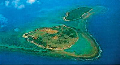
This aerial view shows Aragusuku's twin islets, Kamiji and Shimoji, accessible to each other at low tide.
Here's something else. Aragusuku “Island” is, in fact, two islands. They're close by one an-
other, so close that they're usually referred to as one, but in local dialect they're called Panari
(
パナリ
), which means “separated” or “apart.” At low tide you can walk over a shallow cor-
al shoal about 1,475 feet (450 meters) from one to the other. History has it that they were
originally one island. In the 17th century a tsunami broke them apart and killed most of the
inhabitants.
If not referring to the two islands collectively as Panari, the northern larger islet is named
Kamiji, also Uechi, and the southern islet is known as Shimoji.
KAMIJIJIMA
(
上地島
; Kamiji-jima). This islet is the larger of the Aragusuku twins. Its Kanji
characters literally translate as “Upper” or “Over” Land Island, an obvious reference to its