Travel Reference
In-Depth Information
you'll see that the surrounding pastures are grazed by black Ishigaki cattle, prized for their
marbled beef, so in fact, it's a bucolic and pastoral place as well as a scenic and romantic one.
Just offshore from this northern tip you'll see another one of several islets that we'll men-
tion along the way as we circle around Ishigaki Island.
DAICHI-HANAREJIMA
(
大地離島
; Daichihanaré or Daichi ritō). This vegetation- covered
little rock lies about 1,640 feet (500 meters) offshore straight north from Hirakubozaki. It's
only a speck of an islet, more or less oval-shaped, measuring close to 740 feet (225 meters)
long north to south and 410 feet (125 meters) wide. It may be inhabited by birds or other
creatures but not by man.
The road ends at Cape Hirakubo, so we'll have to turn around and head back. From the
cape it's 19 miles (30 kilometers) due south along the western shore of the Ishigaki Peninsula
and then a tiny bit west to Yonehara (
米原
). There's another excellent beach here, Yonehara
Beach (
米原ビーチ
; Yonéhara bīchi), one of the most popular on the island. It also has public
showers and it's a public campground. A good snorkeling coral reef is a little further offshore
and it, too, is a popular place. But watch it, there are warning signs about the current. It's
rather notorious for strong currents out beyond the reef, so don't swim out too far.
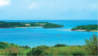
A southern view of beautiful Kabira Bay, protected because of the black pearl industry based there and
thus off-limits to swimmers.