Travel Reference
In-Depth Information
that combines a short hiking trail along a sheltered cove, some free outdoor exhibits on mar-
ine life and an underwater viewing station, which has an admission charge.
From the Miyako Underwater Park we'll continue south about 4 miles (6 kilometers) fol-
lowing along Miyako's west coast, rounding Oura Bay (
大浦湾
; Ōura-wan), then a little more
than 1 mile (2 kilometers) west—follow the signs—to Sunayama Beach (
砂山 ビーチ
; Suna-
yama bīchi; lit. “Sand-Hill Beach”). It's one of Miyako's most picturesque beaches and has a
large natural stone arch that is widely photographed. There are men's and women's changing
rooms and showers at the parking lot. From there it's a bit of a hike up over the sand hill for
which the beach is named.
Our round the island tour is about over. From Sunayama it's only 2.5 miles (4 kilometers)
straight south to downtown Hirara or the port. You'll pass the Nintō-zei Head Tax Stone
and the Tuyumya Nakasone Mausoleum about three-quarters of a mile (1 kilometer) before
reaching town.
Miyako main island is surrounded by, and in many cases attached to, several smaller
satellite islands. Let's mention them now.
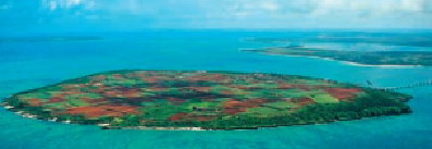
KURIMAJIMA
(
来間島
; Kurima-jima). Kurima is a small islet less than one mile (1.5 kilo-
meters) of the southwestern end of Miyako. It's a fairly uniform oval- or egg-shaped islet,
about 1-1.25 miles (1.5-2 kilometers) in diameter from any given cross-island points. It has
a surface area of about 1 square mile (2.84 square kilometers) and a circumference of 4.5 (7
kilometers). The island's population is estimated at 200. The bridge connecting Kurima to
Miyako is about 7.5 miles (12 kilometers) south of Hirara City. The island has been connec-
ted to the mainland for more than 15 years by the 1-mile (1.5-kilometer)-long Kurima Great
Bridge (
来間大橋
; Kurima Ōhashi).
This aerial view of flat, low-lying Kurimajima shows its almost oval shape and sugar cane fields.