Travel Reference
In-Depth Information
Only about 3 miles (5 kilometers) northwest of Cape Higashi-Henna, just past the Ocean
Links Golf Club, you'll come to what many people think is Miyako's finest beach, the Yoshino
Shore (
吉野海岸
; Yoshinokaigan). Close to another mile (1 kilometer) after Yoshino is the
beautiful Aragusuku Coast (
親城海岸
; Ara-gusuku kaigan), which also has a good beach.
Yoshino has freshwater showers and toilets for visitors. Aragusuku has toilets only.
From the beaches our next stop is almost 9 miles (14 kilometers) northwest at the
Miyakojima City Tropical Botanical Gardens (
宮古島市熱帯植物園
; Miyako-jima-shi Nettai
Shokubutsu-en). Although they are only 2.5 miles (4 kilometers) due east of downtown Hir-
ara, many people find it easier to visit the gardens while touring on this side of the island. The
park is one of Miyako's more popular attractions, perhaps because it is free!
Established in 1964, the park now has over 40,000 trees and plants from 1,600 tropical
species from all over Asia and around the world. The red-blooming flamboyant trees (
Delonix
regia
), also commonly called royal poinciana, are particularly beautiful in April and May.
Six miles (10 kilometers) north of the gardens along the east coast you'll come to the tiny
village of Shimajiri and then Shimajiri Port (
島尻港
; Shima jiri-kō). This small harbor is the
arrival and departure point for the ferry service to Ōgami Island (
大神島
; Ōgami-jima). We'll
mention the island below.
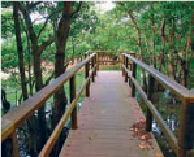
From Shimajiri it's less than three-quarters of a mile (1 kilometer) further north to the
Shimajiri Mangrove Forest (
島尻マングロー ブ林
; Shima jiri Mangurōbu-rin). It's the largest
colony of mangroves on the island and a number of different mangrove species are represen-
ted. There are boardwalk paths through the mangroves which permit access over what would
otherwise be impassible swamp, water and mud.
The numerous species at the Shimajiri Mangrove Forest can be viewed from boardwalks.
From the Mangrove Forest it's not quite 2.5 miles (4 kilometers) north to the top of the
island, which ends in a rather unusual fashion. The northernmost point of Miyako splits, like
the fish tail of a mackerel, and each end of the tail runs out over a 0.75-mile (1-kilometer)-