Travel Reference
In-Depth Information
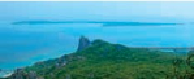
YANAHAJIMA
(
屋那覇島
; Ya-naha-jima). One mile (1.5 kilometers) south of Umigitara Rock
and Izena's southern end we'll find the largest uninhabited islet of Izena. Yanaha is a not too
badly formed crescent in shape, close to 1 mile (1.5 kilometers) long from north to south and
anywhere from 985 to 1,640 feet (300 to 500 meters) wide along almost any point of its east to
west distance. It's a flat island almost completely ringed with sandy beaches. It has an area of a
little less than one-third of a square mile (1 square kilometer), yet a circumference of 3 miles
(5 kilometers). Its eastern cove side inside the crescent rises to a sandy hill with an altitude of
40 feet (12 meters) and is completely covered in vegetation, including many sago palms. Ya-
naha's western outside crescent side is almost barren except for some scrub pandanus trees.
Crescent-shaped, uninhabited Yanaha seen from the southern tip of Izena.
Yanoshitajima, Hinpunkusashi and Kamikusashi, satellite islets of Izena, itself a satellite of Yanaha.
Because the island was inhabited up until World War II, there are the remains of a couple
of small roads and the vestiges of an old reservoir and well that were used at the time. They
can be found in the center of the island. Yanaha is used today as a camping site by Okinawan
Boy Scouts and others. It's open to the public, so anyone may land here and pitch a tent.
YANOSHITAJIMA
(
屋ノ下島
; Ya-no-shitajima). This is really no more than one fairly large
vegetation-covered rock, along with some bordering rock friends, occupying a little dry space
some 660 feet (200 meters) of the northwest tip of Yanaha Islet and 1.25 miles (2 kilometers)
south of Izena Beach. The biggest islet of the little group is round in shape and about 200 feet
(60 meters) in diameter.
HINPUNKUSASHI
(
ヒンプン クサシ
; Hinpun-ku-sashi). A mere 1,360 feet (415 meters) to
the northwest of Yanoshita Rock is this little batch of pointy stones, more a boating hazard