Travel Reference
In-Depth Information
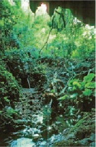
The entrance to Aguni's limestone cave temple.
As the crow flies and by the sea route Agunijima (
粟国島
; Aguni-jima) is almost 40 miles
(64 kilometers) northwest of Naha. There is one round-trip sailing a day on the Aguni ferry.
It leaves Tomari Port at 9:55
AM
and takes two hours to reach the island, arriving just before
noon. The ferry docks at Aguni Port (
粟国港
; Aguni-kō) until 2:10
PM
when it returns to Ok-
inawa, arriving at 4:10
PM
. Aguni also has a small airport (
粟国 空港
; Aguni-kūkō) and there
are several flights a day from Naha. Flying time is only 20 minutes.
Aguni's shape is somewhat that of a rounded triangle or perhaps most of the top half of an
oval. It's a small island, about 2.25 miles (4 kilometers) across east to west at its widest south-
ern end and a little more than 1.5 miles (2.5 kilometers) at its longest north-south points.
It has a surface area of 3 square miles (7.64 square kilometers) and a shoreline of 10.5 (17
kilometers). Although there are no great mountains, the island's highest point is only 315 feet
(96 meters). It would not be accurate to describe it as “flat,” for a good percentage of Aguni is
very hilly, and indeed a good part of its shore is lined with very dramatic cliffs.