Travel Reference
In-Depth Information
ICHIYUNZAIWA
(
イチュンザ岩
; Ichi-yunza iwa; also pronounced as Ichunza iwa). You'll find
this set of rocks about 820-985 feet (250-300 meters) due north from the north-ernmost
little tip of Ōhajima. Depending on the height of the tide, there are anywhere from five or six
to a dozen of them. Of the three largest islets, the easternmost measures about 165 by 300
feet (50 by 90 meters) and is oblong in shape. To its southwest there is a long narrow one,
around 100 feet (30 meters) wide and over 425 feet (130 meters) from end to end, north to
south. Only165 feet (50 meters) above it is the northernmost and largest islet in the group. It
measures about 590 feet (180 meters) from north to south and roughly 330 feet (100 meters)
from east to west. It is an oval in shape but with a number of asymetrical cut-outs and in-
dentations. Of the many other tiny islets, most measure anywhere from 5 to 10 to 20 meters
across. Almost all of the islets, large and small, are entirely covered with dense green vegeta-
tion. Some are connected by sandbars but that depends on the tides.
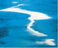
The collection of these rocks is part of a much larger shoal that eventually extends out
several miles. The best-known portion is the bright white sandbar known as Hatenohama-
jima. We'll go there next.
This aerial shot shows Kume to the west, Hateno Beach to the east and Ō and Ōha in the middle.
Torishima, the uninhabited “Bird Island” as seen from Kume's Hiyajō Banta.
HATENOHAMAJIMA
(
ハテの浜島
; also spelled
はての浜島
; Haténo-hama-jima). Beginning
about 2,130 feet (650 meters) offshore from Ōhajima and then extending east about 4 miles
(6 kilometers), this “island” is really a great long sandbar. It is never wider than about 660
feet (200 meters). It is, in fact, a combination of three or four sandbars, each carrying its own