Travel Reference
In-Depth Information
To reach our next destination we'll have to backtrack almost 1 mile (1.5 kilometers) up
the hill to the main coast road (Route 242), then we'll continue east following the signs nearly
1.5 miles (2.5 kilometers) to a parking area where we'll arrive close to the Tachijami Rock (
立
神岩
or
タチジャミ
; lit. “God Established Rock” or “Standing God Rock.” It's a stone mono-
lith approximately 130 feet (40 meters) tall. There's a similar standing God monolith, simil-
arly named and even larger on the island of Yonaguni. From the parking lot we'll hike down
a path about 985 feet (300 meters) until we reach the shore and that's where we'll come to
the stone. While you're here, you can also check out the Tachijami Waterfall (
タチジャミの
滝
; Tachijami-no taki) as it's not far. However, more often than not, unless it's been raining,
the falls will be dry and it's not worth the trouble to find them.
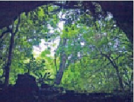
Looking out from the Yajagama Cave, a large, dark grotto filled with stalactites and bats.
From the parking area at Tachijami Rock return to the main road, then continue south-
east a little over 1 mile (1.5 kilo meters). You'll pass through the tiny towns of Uegusuku (
宇
江城
; Ué-gusuku) and Hiyajo (
比屋定
; Hiyajyō) along the way. Just after Hiyajo, on the left,
you'll see a sign for the Sundial Stone (
ウティダ石
or
太陽石
; Utinda-ishi). It's less than 330
feet (100 meters) down a side street from the main road (Route 242). The Japanese-only in-
scription states that it was used as a time measuring device for the villagers for 500 years.
It's not too much, just a sort of a large rock with some writings on it. There are a lot of such
things in Japan. Shortly before this, along the same route, you also would have passed by the
sign for the Tropical Fish Pools (
熱帯魚の家
; Nettai-gyo no ie). If you've never seen saltwater
pools isolated at low tide, usually full of small tropical fish, you might be interested, other-
wise you may wish to give this spot a pass too.