Travel Reference
In-Depth Information
It's not a long hike and it's not a steep climb, only about 820 feet (250 meters) in total, but
from the top you'll get an excellent view back over to Geruma village and out over the south-
ern and western seas. It only takes 5-10 minutes and it's worth the short climb.
About the only road on Fukaji is the 1,640 feet (500 meters) that runs from the Geruma
Bridge to the airport. However, if you look closely, just after crossing over the bridge, on your
right, there is a small road straight back down to the shore. It's about 400 feet (150 meters) in
all and ends at a concrete boat ramp. At the bottom of the little road, near the ramp, and now
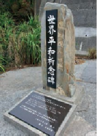
almost under the bridge, is a small World War II commemoration stone. Its date reads March
26, 1945.
The land battle known variously as the Battle of Okinawa, Operation Iceberg and the
Typhoon of Steel began on Easter Sunday, April 1, 1945. It took place over an almost three-
month period and claimed several hundred thousand lives.
In fact, the campaign began a few days beforehand—at this very spot. The first Americans
ashore were soldiers of the 77th Infantry Division, who landed here on Fukaji Island in the
Kerama Islands on March 26. It took five days to secure all the islands. The 77th Infantry lost
27 men and another 81 were wounded. Japanese dead and other casualties numbered over
650; most would not surrender. The operation provided a protected anchorage for the fleet
close to the Okinawa mainland and eliminated the threat from suicide boats from the Kera-
mas. The inscription on the plaque, in English and Japanese, reads: “Men of the 77th Division
salute as the American flag is raised for the first time on the Japanese homeland.”
The first landing site of the Battle of Okinawa.
If these stones could speak, what tales could they tell?