Travel Reference
In-Depth Information
This is the second largest of the Kerama Islands and the most popular. There's relatively fre-
quent ferry service and there's a good deal of tourist infrastructure on the island. Zamam-
ijima (
座間味島
; Zamamijima) is 23 miles (37 kilometers) as the crow flies from Naha Tomari
Port to the port at Zamami, but sea routes as they are, with Tokashiki blocking the way to the
east, it's closer to 30 miles (50 kilometers) sailing distance. The fast ferry takes 50 minutes,
the slower vehicle ferry 90 minutes.
Zamami's geography makes it a particularly difficult island to describe as it has no easily
defined shape. A map gives a better picture. Let's try saying it this way: from east to west it
spans a little over 3 miles (5 kilometers). From north to south it covers almost 2.5 miles (4
kilometers). That might equal 8 square miles (20 square kilometers) but take away all the little
bays, coves, inlets, peninsulas, capes and points in between and it looks more like a mangled
slice of Swiss cheese. Thus, its area is only 2.5 square miles (6.66 square kilometers) although
its circumference is an extraordinary 15 miles (24 kilometers)! Talk about a contorted coast-
line. It makes Zamami a very interesting island on which to drive around. It's relatively hilly
too; the highest point is 528 feet (161 meters).
The easternmost cape of Zamami Island.
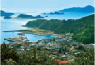
Zamami Port from the Takatsukiyama Lookout. The upper portion of the photo shows, from left to right,
the northern tip of Aka, Gahijima, the Ijakaja Rocks and Yakabijima.
On arrival at Zamami Port (
座間味港
; Zamami-kō), you'll be greeted by a half- sub-
merged humpback whale statue in the harbor, a little reminder that you're in whale watching