Travel Reference
In-Depth Information
Hanarijima, or “Solitary” Island, at the southern end of Tokashiki, a collection of rocks.
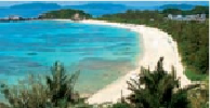
There are beautiful beaches all over Tokashiki but two of the best are at Aharen and Tokashiku.
HANARIJIMA
(
離島
; Hanari-jima). Rounding the southern end of Tokashiki and coming
around the western side there's one final islet about 2,620 feet (800 meters) offshore from the
village of Aharen, its beach and the fishing port. It's actually a collection of a number of rocks
but three are quite large. All are more or less connected by sandbars and that's why the islet
bears but one name. Overall, it measures almost exactly 1,970 feet (600 meters) long from top
to bottom and about 985 feet (300 meters) from side to side at its widest point. The largest
islet of the big three is the one at the center; it's about 985 feet (300 meters) in diameter in all
directions. The topmost northern islet measures about 985 by 740 feet (130 by 225 meters).
The southern islet is about 330 feet (100 meters) across. The single name of the three main
islets, plus all the adjacent rocks, translates as “Solitary” or “Isolated” Island and can also be
pronounced as Banarijima.
That about does it for Tokashiki and its immediate neighbors. Therefore, we are finished
here. Let's travel west to Zamami and have a look over there.
At their very closest points, only 1.25 miles (2 kilometers) separate the northern-most
tip of Tokashiki from the easternmost point of Zamami. But unless you can swim the dis-
tance—or hire a local fisherman to take you—you'll have to backtrack on the ferry to Naha,
wait, maybe overnight, and take another ferry out to Zamami. So close, yet so far away.
The glass-bottomed Yellow Submarine sailing out of Tokashiki's Aharen Port.
7
ZAMAMIJIMA
座間味島