Travel Reference
In-Depth Information
you can visit. You can even drink it! You'll see a sign for Uganhama Utaki. Follow the path
down a fairly long flight of concrete steps. At the bottom is a small cave near the base of the
rocks, and inside is a cool, fresh water spring. Try the water. It's delicious. There's something
resembling a stone urn full of coins and incense sticks in the cave. From here, it's only a few
meters to your own private beach. There's rarely anyone around and the sand is perfect. It's
clean and smooth, not ridden with sharp bits of broken coral.
We'll leave Kudakajima now, but notice on our return, about halfway back to Okinawa-
hontō on our left, a little over a mile (2 kilometers) south, is a small islet. This is Kumaka
Island. We'll discuss it next.
16
KUMAKAJIMA
クマカ島
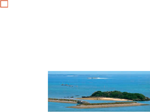
An uninhabited islet, (Kumakajima (
クマカ島
; Kumaka-jima) is 1.5 miles (2.5 kilometers)
offshore from Okinawa's Chinen Peninsula and just over 2 miles (3 kilometers) from
Kudakajima's harbor, in other words, more or less midway between the two. Basically, it's an
ovular sandbar with a central rocky section covered in vegetation. Including its sand, the islet
is about 500 feet (150 meters) long by 200 feet (60 meters) wide. Not including its sand, the
rock and vegetative hard core of the islet is a rough circle about 200 feet (60 meters) in dia-
meter. There's a derelict bunker on its southern side, built during World War II. During the
summer, private boats from Chinen Harbor take beach-goers out here for the day.
Immediately beyond the tsunami barriers, the first small island on the right is Adochijima; to its left rear
is Tamataiwa; to their right rear is Komakajima; and to Komakajima's rear left is Kudakajima.