Travel Reference
In-Depth Information
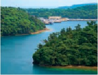
Unten Port at center, with Yagaji Island on the right separated from the Okinawa mainland by a narrow
sea channel and a small inland bay.
8
YAGAJIJIMA
屋我地島
We are actually only 720 feet (220 meters) over the water from a very interesting and remote
place, but we won't be able to get there for a while. Due east from Unten Port is the little
island of Yagajijima (
屋我地島
; Yagaji-jima). At this point, it's separated from the Okinawan
mainland by a narrow sea channel. Further south it's separated by a small bay. The island is
connected to the mainland by two bridges, one on the east, and a new one on the west. Dir-
ectly across the channel, on a little jutting point of land, are the graves of two French seamen
who died while visiting here in 1846. It's called Oranda Baka (
オランダ墓
; Okinawan pro-
nunciation of “Hollanders' Grave”). Although we're very close to it, it's unreachable for the
moment, unless we start swimming. We'll visit the gravesite when we visit Yagaji Island.
After leaving Unten Port, and after 1.75 miles (3 kilometers) of local roads, we'll return to
the Northern Motobu Loop Road, Route 505, and head southeast. At the intersection where
the local road joins 505, you'll see signs and a brand-new highway (Route 248) running due
east. The road was built to connect to the new west-side bridge to Yagaji. Formerly, the is-
land's only road access was via its east-side bridge. Now there are two. We'll visit the is-
land and its two adjacent neighboring islands later. For now, it doesn't make much difference
which way we return to Route 58 and the way north. If we stay on the Motobu Loop Route
505 until it ends at the intersection of Route 58, it's 7.5 miles (12 kilometers) from Unten Port
or if we take the new bridge and cut across Yagajijima and Oujima, it's 6 miles (10 kilomet-
ers). In either case, the intersection at Route 58 marks the northeastern end of the Motobu
Peninsula. The Route 58 Highway comes up 4 miles (6 kilometers) from Nago, although it
starts much earlier, in Naha. It more or less follows the island's west coast all the way to Hedo
Point.