Travel Reference
In-Depth Information
4
TOKUNOSHIMA
徳之島
For the Ryukyus, Tokunoshima (
徳之島
; Tokuno-shima) is a fairly large island (the second
largest of the Amamis) as it has an area of 96 square miles (248 square kilometers) and a cir-
cumference of 52 miles (84 kilometers). Depending on your point of view, it's a rectangle or
an oval. It spans almost exactly 15 miles (24 kilometers) from north to south and anywhere
from 5-8 miles (8-13 kilometers) east to west. Tokuno also has a large population of about
26,750. The island is divided administratively into three “towns” : Tokunoshima (
徳之島町
;
Tokunoshima-chō), Amagi (
天城町
; Amagi-chō), and Isen (
伊仙町
; Isen-chō). The largest is
Tokunoshima Town whose village is called Kametsu (
亀津
; Kamétsu). This is where the main
port is located and where most of the island's hotels, restaurants and other services are found.
It's on Tokuno's Pacific Ocean side.
Tokuno Island has a small airport, (
徳之 島空港
; Tokuno-shima-kūkō), which is located
on the island's northwest side, approximately 15 miles (24 kilometers) driving distance from
Kametsu. There are two flights a day to Amami-Ōshima (25 minutes) and two daily flights to
Kagoshima (one hour). There is occasional service to Naha, Okinawa through Okinoerabu.
Tokunoshima's air terminal and control tower.
The island is well served by the alternating “A” Line and Marix Ferries, which run daily
from Okinawa to Kagoshima and vice versa. Sailing time south from Nazé Port is about three
hours and 30 minutes. Sailing north from Naha, Okinawa, it takes the best part of a day, al-
most 10 hours, as the ferry stops at Motobu Port, Yoron and Okinoerabu along the way.
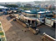
The ferry usually docks at the marine terminal at Kametsu's Kametoku Port (
亀徳港
;
Kamétoku-kō), but when the Pacific Ocean is stormy, the ferries often dock at Hetono Port
(
平土野港
; Hétono-kō) on the island's East China Sea side. Hetono lies just below the airport.
Ryukyu Bullighing