Geoscience Reference
In-Depth Information
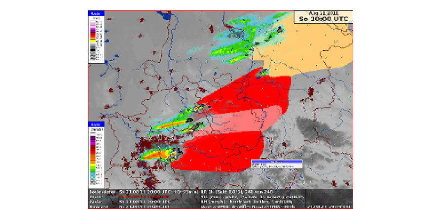
Fig. 17. An example of NowcastMix. It combines and merges the output from several
nowcasting systems into a hazard map.
Since there are several nowcasting systems avaliable, NowCastMIX processes these
available nowcast products together in an integrated grid-based analysis, providing a
generic, optimal warning solution with a 5-minute update cycle. The products are
combined using a fuzzy logic approach (James et al 2011). The method includes estimates
for the storm cell motion by combining raw cell tracking inputs from the KONRAD and
CellMOS systems with vector fields derived from comparing consecutive radar images.
Finally, the resulting gridded warning fields are spatially filtered to provide regionally-
optimized warning levels for differing thunderstorm severities for forecasters. NowCastMIX
delivers a synthesis of the various nowcasting and forecast model system inputs to provide
consolidated sets of most-probable short-term forecasts (Fig. 17).
6.11 Japan - JMA
Japan Meteorological Agency initiated their hazardous wind warning program in 2007. A
hazardous-wind-possibility-index is calculated based on the NWP prediction of wind and
radar reflectivity exceeding a threshold. An innovation is the use of a template matching
technique for the detection of mesocyclones. Rankine vortex and divergence flow field
templates of different intensity and spatial scale are generated and matched to the radial
velocity field. This is done every five minutes. Detections on two consecutive time steps are
required as a quality controlled metric. Then the two estimates are combined every ten
minutes to estimate a hazardous wind potential. Nowcasting is based on a motion analysis.
Different thresholds are statistically established and the success ratio (1-FAR) and the
probability of detection (POD) are used to categorize the hazard level (Table 7). If level 2 is
exceeded (see Fig. 18), then it alerts a forecaster to issue Hazardous Wind Watch. A
forecaster may ignore the level 2 information, when: (i) the storm is near the boundary of a
warning area and it will be out before the time of warning or (ii) the quality of radar data
seems poor (e.g. AP or sea clutter). A forecaster can issue a warning at level 1 when (i)
reliable report of a tornado/tornadoes and/or and (ii) strong gust (say, greater than 30 m/s)
caused by a convective cloud.