Geoscience Reference
In-Depth Information
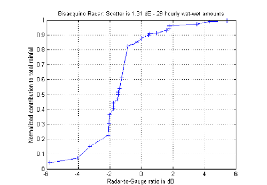
Fig. 14. As for Fig. 12, but for 29 samples with both R and G 0.4 mm/h.
4.4 Quantitative precipitation estimation for the Torino radar
The Torino radar is located on the roof of the Politecnico di Torino (Electronics and
Telecommunications Department): its latitude is 45°.063; the longitude is 7°.660; the altitude
is 275 m above Mean Sea Level (MSL).
For the quantitative evaluation of the radar estimates we have been using three rain gauges:
Castagneto Po, Ciriè and Nichelino. The observation period is based on 42 hours.
For the rain gauge of Castagneto Po, the radar visibility is similar to that of Palermo radar
versus Altofonte gauge, although the range is considerably longer: 21.1 km. As it can be seen
from Fig. 15 (left picture), which shows the radar-gauge profile, the ground clutter
contamination at the gauge location should be negligible since the device is luckily just
behind the top of the hill: this means that Torino radar echoes above the gauge are at least
ground-clutter-free. For the rain gauge in Ciriè, the range is 18.7 km, while the situation is
worse in terms of ground clutter: the gauge location (Fig. 15, right) is, in fact, visible from
the radar site. For the Nichelino gauges the situation is similar.
For what concerns QPE, we have at our disposal data from the 3 gauges during the same 42
hours (April 2011). During these 126 hours the Gauge (Radar) total amounts was 121.7
(114.2) mm, which corresponds to an “overall Bias” of 0.3 dB (radar underestimation).
Out of 126 analyzed hours, in 63 (45) cases the Gauge (Radar) derived hourly rainfall
amount was larger than 0.4 mm/h (see the next Sec. 4.4.1 and Table 4 for more details).